|
Over the Horizon Radar |
||||||
|
..
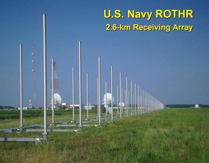
FROM: AN/TPS-71 ROTHR (Relocatable Over-the-Horizon Radar) - FAS.ORG Fleet Surveillance Support Command was established in July 1987 to operate the Navy's Relocatable Over-the-Horizon Radar (ROTHR) in support of Fleet units worldwide. This unique radar system was originally designed to provide tactical warning to battle group commanders of air and surface threats at an extended range allowing time for responsive engagement. Two US Navy high-frequency (HF) over-the-horizon (OTH) radars known as ROTHR (Relocatable Over-the-Horizon Radar) are operated at Corpus Christi TX and Chesapeake VA, with coverage of the Caribbean Sea and portions of the Atlantic Ocean and the Gulf of Mexico. The ROTHRs in Virginia and Texas are presently in full-time use for counter-narcotics surveillance, and a third is scheduled for installation in Puerto Rico in the near future.
A prototype ROTHR system was installed on the isolated Aleutian Island of Amchitka, Alaska, where it surveilled the eastern coast of Russia 24 hours a day, seven days a week from April 1991 to March 1993.Amchitka ROTHR U.S. Navy Base provided essential base support services for the 235-person Navy station at Amchitka Island, 1,400 miles southwest of Anchorage in the Aleutian Chain, from December 1988, until the base's closure in 1993. The system on Amchitka was dismantled at the end of the Cold War, but the first production system was installed in Chesapeake, Va., and declared operational in April 1993 in a counter-drug role in support of U.S. Atlantic Command. A second system was installed in Texas and became operational in July 1995. The FSSC team of officers, enlisted, civilian and contractor personnel operate and support ROTHR from Naval Security Group Activity, Northwest in Chesapeake, where the Operations Control Center and the Receiver Site are located.
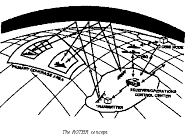
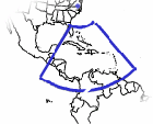
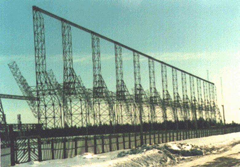
The ROTHR Virginia surveillance area covers more than 2.2 million square miles of the Caribbean extending north-south from southern Florida to the northern coast of South America and east-west from the western coast of Central America to the Lesser Antilles. This coverage is achieved using 5-to-28-MHz radio waves that reflect from the ionosphere. ROTHR is a land-based, high-frequency (HF) radar which can cover a 64-degree wedge-shaped area at ranges of 500 to 1,600 nautical miles. This extended range is achieved when transmitted HF energy is refracted by the ionosphere onto distant targets. The faint energy reflected back from these targets (backscatter) is detected by the radar receive antenna after returning along the refraction path. The surface of the earth and the targets in the area of interest reflect some of this energy back through the ionosphere to a separate receive site, where it is processed to generate target track information.
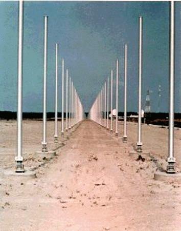
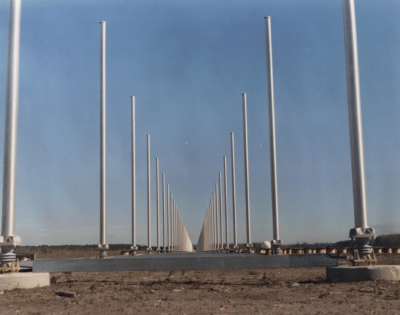
The High Frequency Band (3 to 30 MHz) is a candidate for radar because it enables surface to surface radar to target distances well beyond the horizon. Radar to target ranges of 1000 nmi and more are typical. Use of the 10 to 60 meter wavelengths associated with HF radar requires physically large antennas. Each ROTHR achieves a nominal half degree azimuth angular resolution with a 2.58-km-long linear phased receiving array consisting of 372 twin-monopole elements. Each monopole pair has a receiver and analog-to-digital converter attached to it. A digital beamformer forms 18 beams which are then Doppler processed to separate the moving targets from the ground clutter. Range resolution is achieved by transmitting a 25-kHz continuous frequency-modulated waveform. A radar resolution cell on the ocean surface is therefore about 6 km in range by about 15 km in azimuth, for the frequency and range used. Radar frequency is variable and is selected using real-time sweep frequency ionospheric soundings.
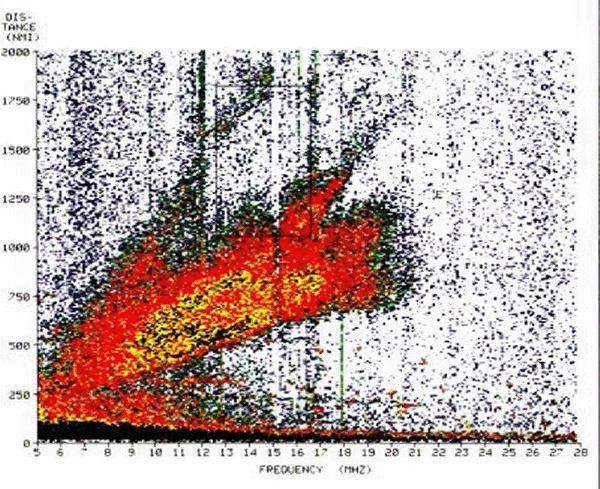
The propagation path is by ionospheric refraction which provides a "mirror" but with considerable variability. This variability is not predictable on a short-term basis; in addition, target illumination is generally by multiple paths. Tracking information thus has varying degrees of accuracy due to the changes and uncertainties of the ionosphere caused by factors such as the time of day, season, sun spot number, and other solar activity. HF radar must measure and adapt to the environment in real time, and oblique backscatter soundings are routinely taken.
Because the existing Over-the-Horizon Radar Systems were originally designed to perform a military mission and not a counterdrug mission, enhancements to provide a better capability to provide surveillance are being developed by the DoD Counterdrug Technology Development Program. A series of adaptive waveforms have been developed to deal with the problem of Spread Doppler Clutter and its impact on Relocatable Over-the-Horizon Radar (ROTHR) systems for the ARPA sponsored Counterdrug Surveillance and Interdiction Program. The class of waveforms developed and demonstrated are non-recurrent waveforms with quadratic phase coding (NRWF/QPC). The waveforms were tested at Rome Laboratory sites in Ava (transmit) and Verona (receive) looking south into the Caribbean. During periods of SDC, where targets detections would not be possible, the use of the new waveforms shifted the SDC out of the area of interest to allow target detections. SOURCE: AN/TPS-71 ROTHR (Relocatable Over-the-Horizon Radar) - FAS.ORG |
||||||
Related Links:
|
||||||
..
|
||||||
|
..
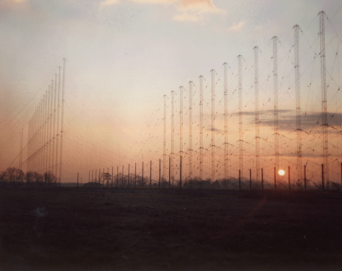
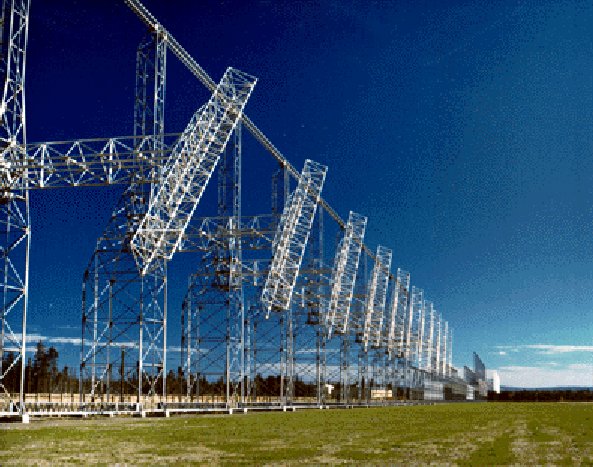
FROM: AN/FPS-118 Over-The-Horizon-Backscatter (OTH-B) Radar The U.S. Air Force's over-the-horizon-backscatter (OTH-B) air defense radar system is by several criteria the largest radar system in the world. Six one-million-watt OTH radars see far beyond the range of conventional microwave radars by bouncing their 5-28-MHz waves off the ionosphere, an ionized layer about 200 km above the earth. It was developed over 25 years at a cost of $1.5 billion to warn against Soviet bomber attacks when the planes were still thousands of miles from US air space. In 1970 Air Force Rome Air Development Center [RADC] engineers developed and constructed components for a frequency modulation/continuous wave (FM/CW) radar capable of detecting and tracking objects at over-the-horizon ranges. The radar installation and evaluation was accomplished on 15 September, while flight tests of a Beverage array antenna were completed on 30 September. On 30 October 1970 the radar and the Beverage array were integrated and operated as a single system for the first time. The Department of Defense initially planned a central sector radar facing south, and an Alaska System facing north, to complement OTH-B radars on the east and west coast to detect enemy bombers and cruise missiles. With the end of the Cold War the military requirement for the central-sector radar had largely disappeared, and it was being pursued now almost exclusively for the drug interdiction mission. The Congress found this system to be redundant and unnecessary for this effort. The total value of the ceiling price of that contract for the first and second sectors of the portion of the OTH-B radar program known as the Alaskan System was estimated at $530,000,000. The unexpected cost growth in the deployment of the first sector of the Alaskan OTH-B system defered procurement of the second sector of this system until at least fiscal year 1991. The main reason for the cost growth is the high cost of construction of this type of facility at the site selected by the Air Force. Consequently, the deployment of the Central CONUS system was deferred at least until fiscal year 1992, with land acquisition required no earlier than fiscal year 1991.
With the end of the Cold War, just months after their deployment, the three OTH radars on the West Coast were mothballed, and the incomplete Alaska System cancelled, but the three radars in Maine were redirected to counter-narcotics surveillance. In 1994 the Congress directed the Air Force to continue operating the East Coast OTH-B radar at no less than a 40 hour per week schedule, and to ensure that all OTH-B tracking data was transmitted directly to DOD and civilian agencies responsible for providing counterdrug detection and monitoring support to law enforcement agencies. In order to utilize the full potential of this wide-area sensor, the Congress directed DOD to (1) assist the Air Force in linking the East Coast OTH-B radar site data directly to users, including but not limited to the U.S. Customs/Coast Guard C3I Center, Miami; Joint Task Force 4 Operations Center, Key West; U.S. Southern Command Operations Center, Key West; and U.S. Southern Command Operations Center, Panama; and (2) fully cooperate with efforts of other government agencies to utilize the dual-use capabilities of this system for remote environmental and weather monitoring and other purposes. The Air Force maintains the six East Coast and West Coast OTH-B radars in a state called ?warm storage,? which preserves the physical and electrical integrity of the system and permits recall, should a need arise. It would require at least 24 months to bring these first generation OTH-B radars out of caretaker status and into an operational status-if such a decision to do so were made. Major upgrades costing millions of dollars would be necessary to bring the outdated technologies up to modern standards. The incremental cost of operating the East Coast OTH-B system for environmental research and services is about $1.0M to $1.5M per year. The environmental monitoring aspects of the system are unclassified. Similar coverage in the eastern Pacific could be obtained at about the same cost.
In 1991, NOAA recognized the potential of these military relics of the cold war for environmental monitoring and asked the Air Force's permission to look at the part of the radar echo that the Air Force throws away -- the ocean clutter. NOAA's tests showed that this clutter can be processed to extract ocean surface wind direction over huge, data-sparse ocean areas -- vital information that affects climate and the ocean's circulation. Tropical storms and hurricanes were tracked, and a system for delivering radar-derived winds to the National Hurricane Center was developed. The combined coverage of the six OTH-B radars is about 90 million square kilometers of open ocean where few weather instruments exist. Recent tests have also demonstrated OTH radars ability to map ocean currents. Specifications
|
||||||
| FAIR USE NOTICE: This page contains copyrighted material the use of which has not been specifically authorized by the copyright owner. Pegasus Research Consortium distributes this material without profit to those who have expressed a prior interest in receiving the included information for research and educational purposes. We believe this constitutes a fair use of any such copyrighted material as provided for in 17 U.S.C § 107. If you wish to use copyrighted material from this site for purposes of your own that go beyond fair use, you must obtain permission from the copyright owner. | ||||||
|
|