|
The Enigmas on Earth Impact Craters on Earth |
|||||
|
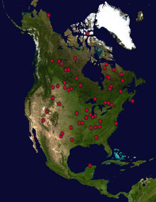
North America Part One .
Earth Impact Database - The biggest collection of Earth Impact Craters by the University of New Brunswick, Canada Visit Also:
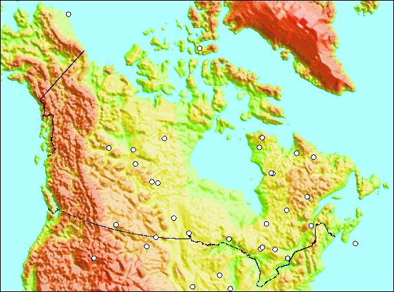
North American Impact Craters
|
|||||
|
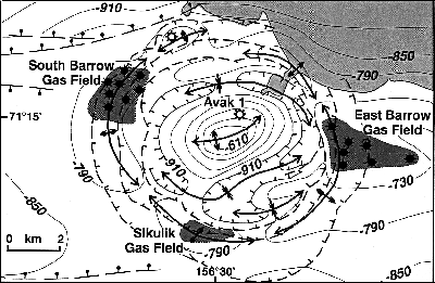
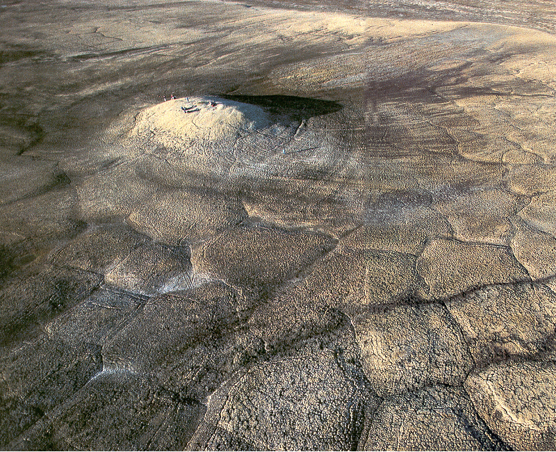
Avak 1 Crater Alaska, USA .
Avak is an impact
crater near Barrow, Alaska in the United
States. It is 7 miles (12 km) in diameter and the
age is estimated to be
less than 95 million years, placing it in the
Cretaceous period or later.
The crater is partly on land and partly in the
ocean; the land portion
is not exposed to the surface, being covered by
sediment from the Pleistocene
and Pliocene epochs.
The crater was drilled in 1951 and 1952 to a depth of 4,019 feet (1,225 m), and the cores that were obtained confirmed an impact origin. The crater is believed to contain commercially viable deposits of hydrocarbons.- Source: Wikipedia |
|||||
|
.
|
|||||
|
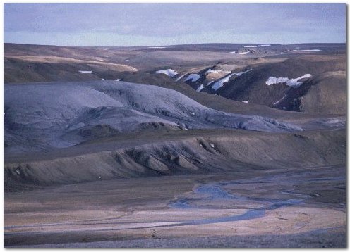
Haugton Crater Devon Island, Nunavut, Northwest Territories, Canada .
NASA - The
Haughton-Mars Project (HMP) is an international
interdisciplinary field research project centered on
the scientific study
of the Haughton impact structure and surrounding
terrain, Devon Island,
High Arctic, viewed as a terrestrial analog for
Mars. The rocky polar desert
setting, geologic features and biological attributes
of the site offer
unique insights into the possible evolution of Mars
- in particular the
history of water and of past climates on Mars -, the
effects of impacts
on Earth and on other planets, and the possibilities
and limits of life
in extreme environments. In parallel with its
Science program, the HMP
supports an Exploration program aimed at developing
new technologies, strategies,
humans factors experience, and field-based
operational know-how key to
planning the future exploration of the Moon, Mars
and other planets by
robots and humans.
- Source NASA
Haughton-Mars Project (HMP)
See Also
See Also:
|
|||||
|
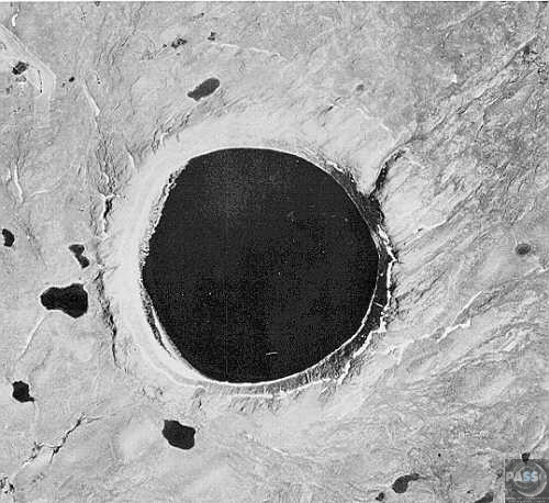
Nicholson Crater and Lake Northwest Territories, Canada .
Nicholson is a meteor crater in the Northwest Territories, Canada. It is 12.5 km in diameter and the age is estimated to be less than 400 million years (Devonian or earlier). The crater is not exposed to the surface. |
|||||
|
Pilot Crater and Lake Northwest Territories, Canada. .
Pilot crater is a meteor crater in the Northwest Territories, Canada, just north of the Alberta border and near Fort Smith. It is 6 kilometres in diameter and the age is estimated to be 445 ± 2 million years (Upper Ordovician). The crater contains Pilot Lake, a pristine fresh-water lake that covers 43 square kilometres (16 mi²) and is 90 metres (300 ft) deep. Lake trout, northern pike, whitefish and pickerel are plentiful, supporting a summer market for recreational fishing. - Source: Wikipedia
|
|||||
|
Steen River Crater Alberta, Canada Steen River is an impact structure (astrobleme) in Alberta, Canada. It is 25 km in diameter and the age is estimated to be 91 ± 7 million years (Lower Cretaceous). The crater is not exposed to the surface. The crater was partially eroded prior to burial, and lies under 200 m of sediments. |
|||||
|
Carswell Crater Saskatchewan, Canada Carswell is an impact crater in Saskatchewan, Canada. It is 39 km in diameter and the age is estimated to be 115 ± 10 million years (Lower Cretaceous). The crater is exposed to the surface. |
|||||
|
Elbow Crater Saskatchewan, Canada Elbow is a meteor crater in Saskatchewan, Canada. It is 8 km in diameter with an age estimated to be 395 ± 25 million years (during the Devonian Period). The crater is not exposed to the surface. |
|||||
|
Viewfield Crater Saskatchewan, Canada Viewfield is an impact crater in Saskatchewan, Canada. It is 2.5 km in diameter and the age is estimated to be 190 ± 20 million years (Late Triassic). The crater is not exposed to the surface. |
|||||
|
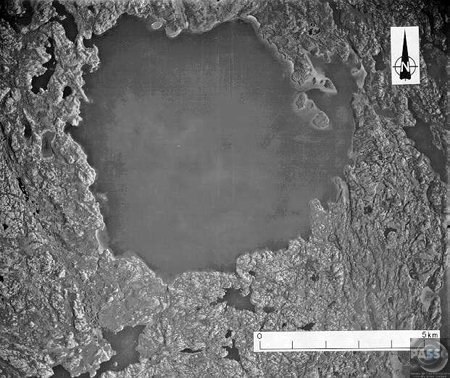
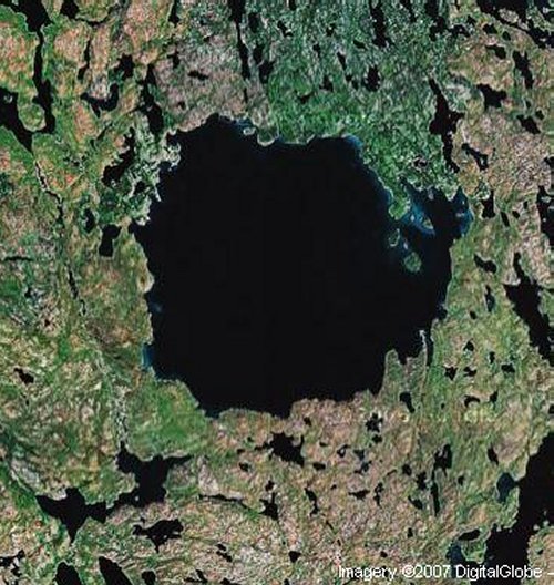
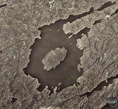
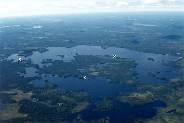
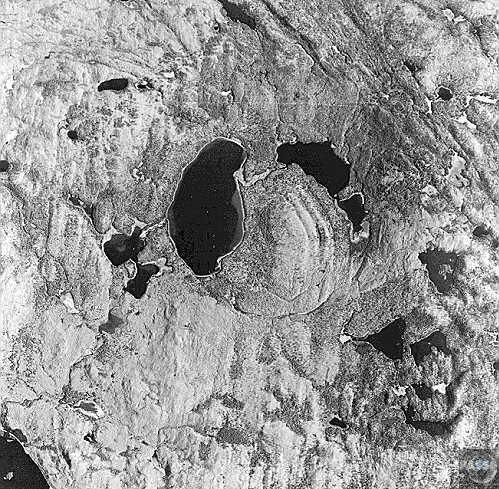
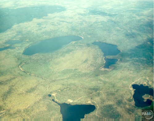
Gow Crater and Lake Saskatchewan, Canada .
Gow is a meteor crater in Saskatchewan, Canada. It is 4 km (2.5 mi) in diameter and the age is estimated to be less than 250 million years (Triassic or later). The crater contains a classic crater lake with an island formed by the central uplift. |
|||||
|
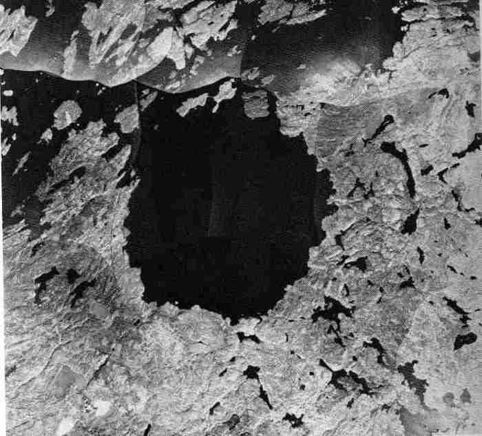
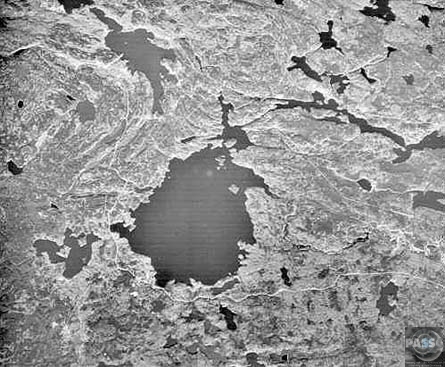
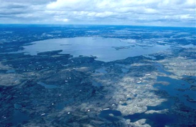
Deep Bay Crater Saskatchewan, Canada .
This crater consists
of a near-circular bay, about
5 kilometers (3 miles) wide and 220 meters (720
feet) deep, in the otherwise
shallow Reindeer Lake. Such deep circular lakes are
unusual in this region,
which is dominated by the shallow gouging of glacial
erosion. The circular
shoreline, at a diameter of 11 kilometers (6.8
miles), is partially surrounded
by a ridge with heights to 100 meters (328 feet)
above the lake surface.
The diameter of this ridge, ~13 kilometers (8
miles), is likely the outer
rim of the impact structure. The structure was
formed in Precambrian metamorphic
crystalline rocks with a conspicuous northwest
trending fabric. Although
not obvious from the surface, Deep Bay is a complex
impact structure with
a low, totally submerged central uplift. Samples
obtained in the 1960's
from drilling into the central structure revealed
shocked and fractured
metamorphic rocks flanked by deposits of
allocthonous, mixed breccias.
(Courtesy NASA/LPI)
|
|||||
|
Saint Martin Crater Manitoba, Canada Saint Martin is an impact crater in Manitoba, Canada. It is 40 km in diameter and the age is estimated to be 220 ± 32 million years (Triassic). The crater is not exposed to the surface. |
|||||
|
West Hawk Crater and Lake Manitoba, Canada .
West Hawk is a meteor crater in Manitoba, Canada. It is 2.44 km in diameter and the age is estimated to be 351 ± 20 million years (Mississippian). The crater is not exposed to the surface. The crater forms the main central portion of West Hawk Lake. |
|||||
|
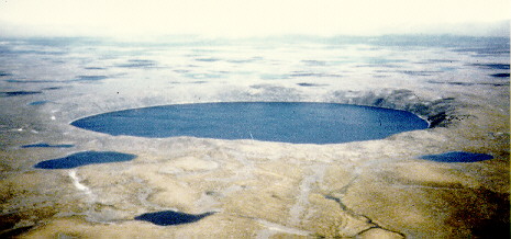
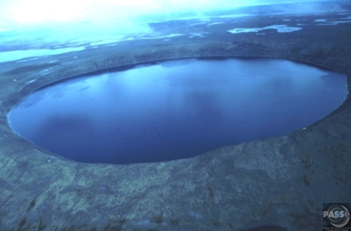
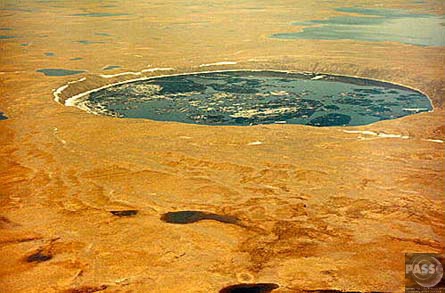
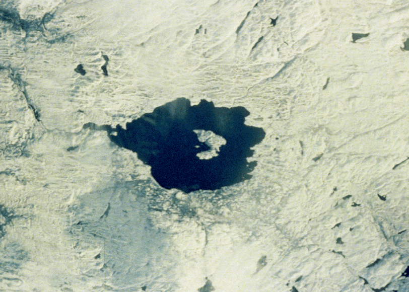
Pingualuit Crater (Nouveau / New Quebec, Chubb) Quebec, Canada .
The Pingualuit
crater (also known as the Nouveau / New
Quebec or Chubb crater) lies near the northern tip
of the Ungava peninsula,
Quebec, Canada (Lat 61° 17' N, Long 75° 40' W). It
is a classic
example of a simple relatively small crater. It is
about 3.4 km in diameter
and almost perfectly circular with a raised rim up
to 163 metres above
the lake surface in the central flooded depression.
The lake is 252 metres
deep, the deepest in Quebec. The crater, which
occurs in crystalline shield
rocks, was first recognised as an impact structure
in 1950. The impact
that produced this crater occurred about 1.4 million
years ago, that is
just before the glaciers covered this area
(Courtesy Geological Survey
of Canada) - Source
The New Quebec
Crater, or Pingualuit Crater, is a young
meteor crater, by geological standards, located in
the Ungava Peninsula
of Quebec, Canada. It is 3.44 km in diameter and the
age is estimated to
be 1.4 ± 0.1 million years (Pliocene). The crater is
exposed to
the surface, and a 250 meter deep lake fills the
depression. The New Quebec
crater is located at latitude 61°16'36" North,
longitude 73°40'41"
West. 61°16'36"N, 73°40'41"W
|
|||||
|
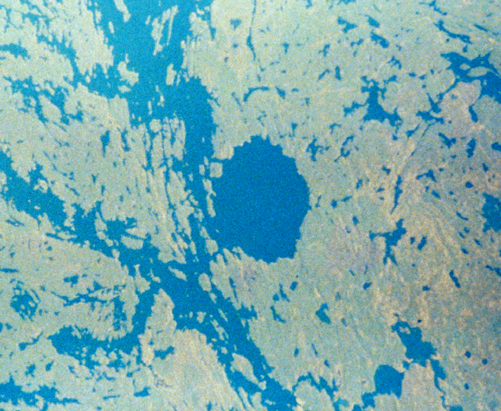
Couture Crater and Lake Quebec, Canada .
Couture is a lake in Northern Quebec, Canada. Most of the lake covers an 8 km in diameter impact crater. The crater is estimated to be 430 ± 25 million years old (Silurian). |
|||||
|
La Moinerie Crater and Lake Quebec, Canada .
La Moinerie is a
meteor crater in Quebec, Canada. It
is 8 km in diameter and the age is estimated to be
400 ± 50 million
years (Silurian or Devonian). The crater is exposed
to the surface and
filled with water, forming Lac La Moinerie. Glaciers
have eroded many of
La Moinerie crater's original physical features,
including much of the
central uplift.
|
|||||
|
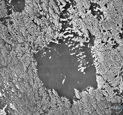
Clear Water Lakes Quebec, Canada .
These twin
circular lakes (large dark features) were formed
simultaneously by the impact of an asteroidal pair
which slammed into the
planet approximately 290 million years ago. The
lakes are located near
the eastern shore of Hudson Bay within the Canadian
Shield in a region
of generally low relief in northern Quebec province.
Notice that the larger
western structure contains a ring of islands with a
diameter of about 10
kilometers that surrounds the center of the impact
zone. They constitute
a central uplifted area and are covered with impact
melts. The central
peak of the smaller Clearwater Lake East is
submerged. The lakes are named
after their exceedingly clear water. Also notice
that the surrounding terrain
shows widespread scarring from glaciation. The
multitude of linear and
irregular shaped lakes (dark features) are the
result of gouging or scouring
action caused by the continental ice sheets that
once moved across this
area. - Source
The lakes fill depressions that are interpreted as paired impact craters (astroblemes). The eastern and western craters are 26 km and 36 km in diameter, respectively. Each crater has same age, 290 ± 20 million years (Permian), and it is believed that they formed simultaneously. The impactors may have been gravitationally bound as a binary asteroid. This suggestion was first made by Thomas William Hamilton in a letter to Sky & Telescope magazine in support the then-controversial theory that asteroids may possess moons. The lakes are actually a single body
of water with
a sprinkling of islands forming a "dotted line"
between the eastern and
western parts. The name is due to the clear water it
holds. There are actually
25 lakes of that name in the province (26 if you
count the "Petit lac à
l'Eau Claire" —the "Small Clearwater Lake"). These
are the largest and
northernmost.
|
|||||
|
Ile Rouleau Crater Quebec, Canada .
Île Rouleau is a meteor crater in Quebec, Canada. It is 4 km in diameter and the age is estimated to be less than 300 million years (Permian or earlier). The crater is exposed to the surface. |
|||||
|
Presqu'ile Meteorite Crater Quebec, Canada .
|
|||||
|
Charlevoix Crater Quebec, Canada .
Charlevoix is an
impact crater in Quebec, Canada. It
is 54 km in diameter and the age is estimated to be
342 ± 15 million
years (Mississippian). The crater is exposed to the
surface. It is filled
with shatter cones, PDF in quartz and feldspar
grains. It is a multi-ringed
basin with a central uplift. Part of the crater is
covered by the St. Lawrence
River. It was discovered to be a meteor crater in
1965 after the discovery
of many shatter cones in the area. Only a
semi-circle of the crater is
left due to the other half being flooded.
The Charlevoix
Meteorite Crater, a multi ringed basin
with a central uplift (Note 2), is located in
southern Quebec on the north
shore of the St. Lawrence River, 105 km NE of Quebec
City. The structure
was identified as a meteorite crater in 1965 with
the discovery of shattercones
in the area. The initial dimensions of the crater
were estimated to have
been 28 km in diameter (the inner circle in the
landsat image) and 10 km
in depth immediately after the impact. The
subsequent post impact crater
collapse created the central peak and peripheral
modification resulting
in a final crater structure of 54 km in diameter
(outer circle in the landsat
image). Erosion has removed the original crater rim,
some of the central
uplift and the crater-fill products but the crater
floor has been preserved.
Thrusting along the St. Lawrence River fault lines
during either the Taconian
or Acadian Orogenies, or both, obliterated the
south-eastern portion of
the crater. An unknown thickness of early
(pre-Charlevoix impact) Palaeozoic
sedimentary rock was then transported over the
obliterated portion of the
crater. Finally the St. Lawrence River flooded the
area leaving the semi-circular
crater remnant. The deepest parts of the St.
Lawrence in this area are
along its interface with the crater. The missing
part of the crater has
not been detected under the St. Lawrence River. The
rocks of Isle aux Coudres,
immediately to the south of the crater in the St.
Lawrence River, are Palaeozoic
sedimentary rocks that have been transported to this
position from the
southeast after the impact - Source
and
more data...
|
|||||
|
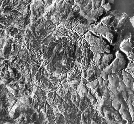
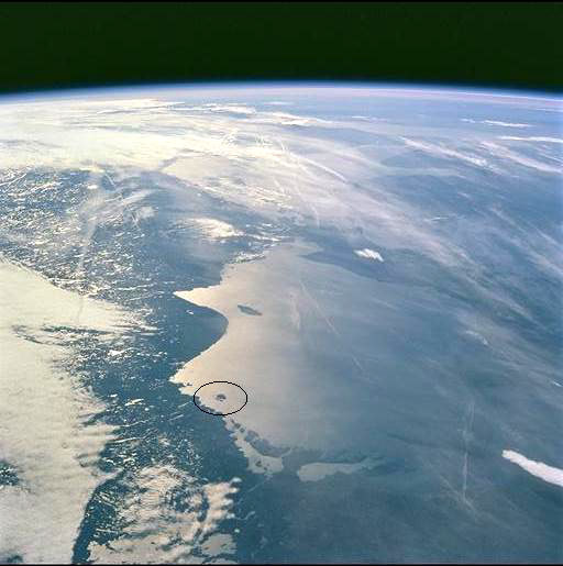
Mistastin Crater and Lake Newfoundland and Labrador, Canada .
This shuttle image
shows a winter view of the Mistastin
Crater, a heavily eroded complex structure. Eastward
moving glaciers have
drastically reduced the surface expression of this
structure, removing
most of the impact melt sheet and breccias and
exposing the crater floor.
Glacial erosion has also imparted an eastward
elongation to the crater
that is particularly evident in the shape of the
lake that occupies the
central 10 kilometers (6 miles) of the structure.
Horseshoe Island, in
the center of the lake, is part of the central
uplift and contains shocked
Precambrian crystalline target rocks. Just beyond
the margins of the lake
are vestiges of the impact melt sheet that contains
evidence of meteoritic
features in quartz, feldspar and diaplectic glasses.
(Courtesy NASA/LPI)
Mistastin crater is a meteor crater in Labrador, Canada which contains the roughly circular Mistastin Lake. The lake's arcuate central island is interpreted to be the central uplift of the complex crater structure. The target rocks were part of a batholith composed of adamellite, mangerite and lenses of anorthosite. There are abundant shock metamorphic features exhibited in the rocks of the island. PDFs, diaplectic glass, melt rocks, and shatter cones have been identified. The lake is approximately 16 km in diameter, while the estimated diameter of the original crater is 28 km. The age of the crater is estimated to be 36.4 ± 4 million years (Eocene). - Source: Wikipedia |
|||||
|
Montagnais Crater Nova Scotia, Canada Montagnais is a meteor crater located on the continental shelf south of Nova Scotia, Canada. The centre is estimated to be located at 42°53'N, 64°13'W. Measuring 45 km in diameter, the crater's age is estimated to be 50.50 ± 0.76 million years (Paleocene). The crater is underwater and not exposed to the surface. |
|||||
|
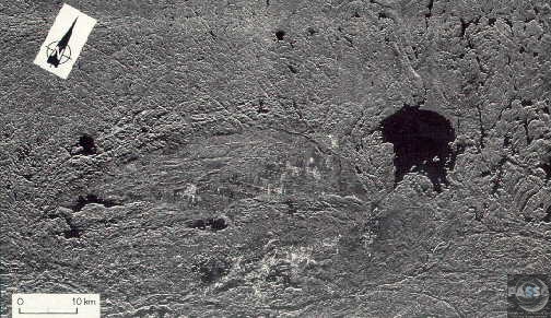
Slate Islands Crater Ontario, Canada .
(Courtesy NASA)
The ~7-km-wide Slate Islands group represents
the heavily eroded central peak of a ~32 km diameter
(from bathymetric
data) complex impact crater. The Slate Islands
meteorite crater is located
in northern Lake Superior ~10 km south of Terrace
Bay and ~150 km east
of Thunder Bay, Ontario. The crater is indicated in
this eastward looking
Shuttle image by a circle representing the
approximate crater rim. Lake
Huron (containing the Can-Am impact crater) and Lake
Erie are also visible
in the background of the shuttle image.
- Source
and
more data... |
|||||
|
Sudbury Crater Ontario, Canada .
The Sudbury Basin,
also known as Sudbury Structure, is
the second largest known impact crater or astrobleme
on Earth, and a major
geologic structure in Ontario, Canada.
The basin is located on the Canadian Shield in the city of Greater Sudbury, Ontario. The former municipalities of Rayside-Balfour and Valley East lie within the Sudbury Basin, which is referred to locally as "The Valley". The urban core of the former city of Sudbury lies on the southern outskirts of the Basin. Formation and structure The Sudbury Basin is 60 km long, 30 km wide and 15 km deep. It was created as the result of a 10 km cometary impact that occurred 1.85 billion years ago in the Paleoproterozoic era. Its present size is believed to be a smaller portion of a 250 km round crater that the bolide originally created. Subsequent geological processes have deformed the crater into the current smaller oval shape. Sudbury Basin would then be the second largest crater on earth, after the 300 km Vredefort crater in South Africa, and larger than the 170 km Chicxulub crater in Yucatán, Mexico which is linked to the extinction of the dinosaurs. The deformation of the Sudbury structure occurred in four main deformation events (by age): 1. the
Penokean Orogeny (1900 Ma)
Throughout the 20th century the origin of the Sudbury Basin was widely disputed Modern uses The large impact crater filled with magma containing nickel, copper, platinum, palladium, gold and other metals. As a result of these metal deposits, the Greater Sudbury area is one of the world's major mining communities. The region is one of the world's largest supplier of nickel and copper ores. Most of these mineral deposits are found on the outer rim of the Basin. Due to the high mineral content of its soil, the floor of the Basin is among the best agricultural land in Northern Ontario, with numerous vegetable, berry and dairy farms located in the Valley. However, due to its northern latitude, it is not as fertile as agricultural lands in the southern portion of the province. Accordingly the region primarily supplies products for consumption within Northern Ontario, and is not a major food exporter.
|
|||||
|
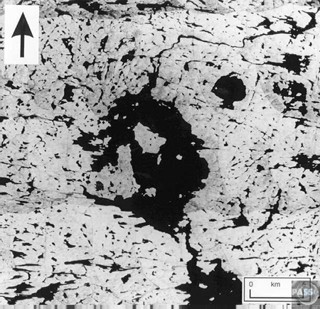
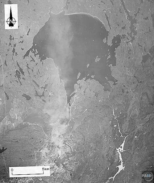
Wanapitei Crater Ontario, Canada .
The Wanapitei
impact structure lies entirely within the
central portion of the 9 km diameter Wanapitei Lake,
visible at the top
center of this landsat image (Note 5, 6). The
structure was identified
as a possible meteorite crater in 1972. It is
classified as a simple crater
because of its estimated diameter of 3 km (E.
L’Heureux et al, 2003) to
~7-8 km (Dence and Polelar, 1972) and because there
is no evidence of a
central uplift in the submerged crater (Dence and
Popelar, 1972). New geological
studies (2003) thus far indicate that if the
observed circular structure
is due to a meteorite impact, it is at most a 3 to 4
km diameter simple
crater (indicated by the circle in the landsat
image). The new diameter
of 3 km has not been widely accepted as yet (E.
L’Heureux, 2003) (Note
2).
- Source
and
more data...
Lake Wanapitei is
a meteor crater lake in Greater Sudbury,
Ontario, Canada. It is located near the large
Sudbury meteor crater but
not related to it.
It is 7.5 km in diameter and the age is estimated to be 37.2 ± 1.2 million years, placing it in the Eocene. It was evident by the mid-1970s that Wanapitei Lake was an impact crater. Remarkably, it lies on the eastern edge of the much older, larger Sudbury structure. Crumbly impact breccia cobbles containing bits of dark glass called suevite are found surrounding the lake,some with Coesite, one of the markers of an impact structure. The suevite is very close in appearance and composition to some of that described from the Ries impact site that formed simultaneously with the smaller Steinheim Crater. It is a popular recreational and residential area in Sudbury, and the lake is the largest in the world completely contained within the boundaries of a single city. The Wanapitei River flows through the lake. There is a provincial park located on the north shore of Lake Wanapitei; this is a non-operating park so there are no facilities. The lake has a number of small islands within it. Named islands include Blueberry, Howie, Wanapitei, MacLennan and Bonanza. The small Wanapitei Ojibwe reserve is also located on the lake's northwestern shore. The lake's name comes from the Ojibwa word waanabidebiing, or "concave-tooth [shaped] water", which describes its shape. A nearby community which takes its name from the river is spelled Wahnapitae. However, the Wanapitei spelling is correct for both the lake and the river. - Source: Wikipedia |
|||||
|
Brent Crater Ontario, Canada .
The Brent crater
is an impact crater located north of
Cedar Lake in Algonquin Provincial Park in the
Nipissing District of Ontario,
Canada. It is 3.8 km in diameter and the age is
estimated to be 396 ±
20 million years (Middle Devonian).
A sign, erected at the site by the Archeological and Historic Sites Board, Archives of Ontario, reads: The Brent Crater: First recognized in 1951 from aerial photographs, the crater is a circular depression about two miles in diameter formed in Precambrian crystalline rocks. Geophysical and diamond drilling investigations show that the crater has a present depth of about 1,400 feet but is partly filled with sedimentary rocks with a thickness of 900 feet. The rocks beneath the crater floor are thoroughly fragmented over a depth of 2,000 feet. Like the similar New Quebec (Chubb) crater, the Brent crater is attributed to the high speed impact of a giant meteorite. It is calculated that the impact released energy equaling 250 megatons of TNT and occurred about 450 million years ago when this area was probably covered by a shallow sea. There is an observation tower on the rim of the crater and a hiking trail leading to the crater floor. There are two small lakes, Gilmour and Tecumseh, located in the crater. Unlike most Algonquin Park lakes, which are usually acidic, the water in these lakes contains bicarbonate; this is thought to be a result of some sedimentary deposits of limestone escaping removal by glaciers in the lower parts of the crater. The crater was named after the
nearby village of Brent.
|
|||||
|
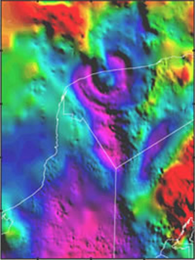
Chicxulub Crater Yucatan Peninsula, Mexico .
This is the one that got the Dinosaurs The Chicxulub crater in the Yucatan peninsula, Mexico, is not visible at the surface of the seafloor. Scientists rely on geophysical images for information about its size and shape. This image shows the variations in the gravity field near the buried impact crater. The image shows ring-like structures that extend to about 280 kilometers (175 miles) from the center. This crater is believed to have formed when an asteroid struck Earth 65 million years ago. This impact is thought to have triggered fires and tsunamis and created a cloud of dust and water vapor that enveloped the globe in a matter of days, resulting in fluctuating global climate changes. The extreme environmental shifts caused a mass extinction of 75% of Earth's species, including the dinosaurs. The Chicxulub crater in the Yucatan peninsula, Mexico, is not visible at the surface of the seafloor. Scientists rely on geophysical images for information about its size and shape. This image shows the variations in the gravity field near the buried impact crater. The image shows ring-like structures that extend to about 280 kilometers (175 miles) from the center. This crater is believed to have formed when an asteroid struck Earth 65 million years ago. This impact is thought to have triggered fires and tsunamis and created a cloud of dust and water vapor that enveloped the globe in a matter of days, resulting in fluctuating global climate changes. The extreme environmental shifts caused a mass extinction of 75% of Earth's species, including the dinosaurs. SOURCE: Lunar and Planetary Institute More Detailed Information: NASA
Planetary
Journal
More Information: NASA
Near
Earth Object Program
|
|||||
| FAIR USE NOTICE: This page contains copyrighted material the use of which has not been specifically authorized by the copyright owner. Pegasus Research Consortium distributes this material without profit to those who have expressed a prior interest in receiving the included information for research and educational purposes. We believe this constitutes a fair use of any such copyrighted material as provided for in 17 U.S.C § 107. If you wish to use copyrighted material from this site for purposes of your own that go beyond fair use, you must obtain permission from the copyright owner. | |||||
|
|


