|
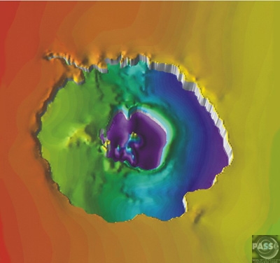
The Enigmas on Earth Impact Craters on Earth |
|||||
|
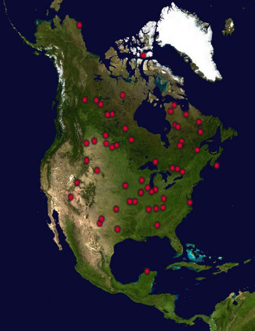
North America Part Two .
|
|||||
|
Chesapeake Bay Crater Virginia, USA .
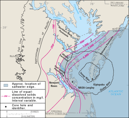
Formation and aftermath During the warm, late Eocene, sea levels were high, and the Tidewater region of Virginia lay in the coastal shallows. The shore of eastern North America, about where Richmond, Virginia is today, was covered with dense tropical rainforest, and the waters of the gently sloping continental shelf were rich with marine life that was depositing dense layers of lime from their microscopic shells. The bolide impacted at a speed of many kilometers per second, punching a deep hole through the sediments and into the granite continental basement rock. The bolide itself was completely vaporised, with the basement rock being fractured to depths of 8 kilometers, and a 'peak ring' being raised around it. The deep crater, 38 km across, is surrounded by a flat-floored terrace-like ring trough with an outer edge of collapsed blocks forming ring faults. The entire circular crater is about 85 km in diameter and 1.3 km deep, an area twice the size of Rhode Island, and nearly as deep as the Grand Canyon. The surrounding region suffered massive devastation. USGS scientist David Powars, one of the impact crater's discoverers, has described the immediate aftermath: "Within minutes, millions of tons of water, sediment, and shattered rock were cast high into the atmosphere for hundreds of miles along the East Coast." An enormous seismic tsunami engulfed the land and possibly even overtopped the Blue Ridge Mountains. The sedimentary walls of the crater progressively slumped in, widened the crater, and formed a layer of huge blocks on the floor of the ring-like trough. The slump blocks were then covered with the rubble or 'breccia'. The entire bolide event, from initial impact to the termination of breccia deposition lasted only a few hours or days. In the perspective of geological time, the 1.2 km-thick breccia is an instantaneous deposit. The crater was then buried by additional sedimentary beds that have accumulated during the 35 million years following the impact. Another, smaller bolide impact site, the Toms Canyon impact crater, lies about 200 miles to the northeast, on the continental shelf off the coast of New Jersey. Having also been dated to the late Eocene, it is possible that this crater may have been formed in the same impact event as the Chesapeake Bay crater. Discovery Until 1983, no one suspected the existence of such a crater buried 300–500 meters beneath the lower part of the Chesapeake Bay and its surrounding peninsulas. The first hint was a 20 centimeter-thick layer of ejecta that turned up in a drilling core taken off Atlantic City, New Jersey, far to the north. The layer contained the fused glass beads called tektites and shocked quartz grains that are unmistakable signs of a bolide impact. In 1993, oil exploration revealed the extent of the crater. Effects on local rivers The continual slumping of the rubble within the crater has affected the flow of the rivers and shaped the Chesapeake Bay. The impact crater created a long-lasting topographic depression, which helped predetermine the course of local rivers and the eventual location of Chesapeake Bay. Most important for present-day inhabitants of the area, the impact disrupted aquifers. The present freshwater aquifers lie above a deep salty brine, making the entire lower Chesapeake Bay area susceptible to groundwater contamination. - Source: Wikipedia |
|||||
|
.
|
|||||
|
.
|
|||||
|
Eastern Tajikistan .
Near the center of this scene is the mountain lake
Kara-Kul, located in eastern Tajikistan, high in the Pamir mountain range
near the Afghan border. The 25-kilometer (16 mi) diameter lake sits at
an elevation of 6000 meters (20,000 ft) above sea level. Kara-Kul was formed
from a meterorite impact approximately 25 million years ago, leaving a
crater with a rim diameter of 45 kilometers (28 mi). Islands formed from
the central uplift can be seen in the northern and southern parts of the
lake. Interestingly, the Kara-Kul impact structure remained unidentified
until it was discovered though studies of imagery taken from space.
|
|||||
|
Quebec, Canada .
|
|||||
|
Yucatan Peninsula, Mexico .
This is the one that got the Dinosaurs The Chicxulub crater in the Yucatan peninsula, Mexico, is not visible at the surface of the seafloor. Scientists rely on geophysical images for information about its size and shape. This image shows the variations in the gravity field near the buried impact crater. The image shows ring-like structures that extend to about 280 kilometers (175 miles) from the center. This crater is believed to have formed when an asteroid struck Earth 65 million years ago. This impact is thought to have triggered fires and tsunamis and created a cloud of dust and water vapor that enveloped the globe in a matter of days, resulting in fluctuating global climate changes. The extreme environmental shifts caused a mass extinction of 75% of Earth's species, including the dinosaurs. The Chicxulub crater in the Yucatan peninsula, Mexico, is not visible at the surface of the seafloor. Scientists rely on geophysical images for information about its size and shape. This image shows the variations in the gravity field near the buried impact crater. The image shows ring-like structures that extend to about 280 kilometers (175 miles) from the center. This crater is believed to have formed when an asteroid struck Earth 65 million years ago. This impact is thought to have triggered fires and tsunamis and created a cloud of dust and water vapor that enveloped the globe in a matter of days, resulting in fluctuating global climate changes. The extreme environmental shifts caused a mass extinction of 75% of Earth's species, including the dinosaurs. SOURCE: Lunar and Planetary Institute More Detailed Information: NASA
Planetary Journal
More Information: NASA
Near Earth Object Program
|
|||||
|
Free State, South Africa STS-51 I-33-56AA .
This crater consists of a near-circular bay, about 5 kilometers (3 miles) wide and 220 meters (720 feet) deep, in the otherwise shallow Reindeer Lake. Such deep circular lakes are unusual in this region, which is dominated by the shallow gouging of glacial erosion. The circular shoreline, at a diameter of 11 kilometers (6.8 miles), is partially surrounded by a ridge with heights to 100 meters (328 feet) above the lake surface. The diameter of this ridge, ~13 kilometers (8 miles), is likely the outer rim of the impact structure. The structure was formed in Precambrian metamorphic crystalline rocks with a conspicuous northwest trending fabric. Although not obvious from the surface, Deep Bay is a complex impact structure with a low, totally submerged central uplift. Samples obtained in the 1960's from drilling into the central structure revealed shocked and fractured metamorphic rocks flanked by deposits of allocthonous, mixed breccias. (Courtesy NASA/LPI) |
|||||
|
Chad, Africa .
The impact of an asteroid or comet several hundred million years ago left scars in the landscape that are still visible in this spaceborne radar image of an area in the Sahara Desert of northern Chad. The concentric ring structure is the Aorounga impact crater, with a diameter of about 17 kilometers (10.5 miles). The original crater was buried by sediments, which were then partially eroded to reveal the current ring-like appearance. The dark streaks are deposits of windblown sand that migrate along valleys cut by thousands of years of wind erosion. The dark band in the upper right of the image is a portion of a proposed second crater. Scientists are using radar images to investigate the possibility that Aorounga is one of a string of impact craters formed by multiple impacts. Radar imaging is a valuable tool for the study of desert regions because the radar waves can penetrate thin layers of dry sand to reveal details of geologic structure that are invisible to other sensors. The image was acquired by the Spaceborne Imaging Radar-C/X-band Synthetic Aperture Radar (SIR-C/X-SAR) on April 18 and 19, 1994, onboard the space shuttle Endeavour. The area shown is 22 kilometers by 28 kilometers (14 miles by 17 miles) and is centered at 19.1 degrees north latitude, 19.3 degrees east longitude. North is toward the upper right. The colors are assigned to different radar frequencies and polarizations as follows: red is L-band, horizontally transmitted and received; green is C-band, horizontally transmitted and received; and blue is C-band, horizontally transmitted, vertically received. SIR-C/X-SAR, a joint mission of the German, Italian and United States space agencies, is part of NASA's Mission to Planet Earth program. This image is in the public domain and is copyright free. - SOURCE: Solar Views |
|||||
|
Namibia, South West Africa .
Located in the Namibia Desert, the raised crater rim
is clearly visible against darker background vegetation. Target rocks include
primarily Precambrian crystalline rocks and modest amounts of younger sedimentary
rocks. Outcrops of impact melt breccias are found exclusively on the crater
rim. The crater floor is covered by broad, shifting sand dunes. This image
shows an oblique view of the crater, from about 150 meters (492 feet) above
ground looking southeast. (Courtesy of W. U. Reimold and LPI)
This space radar image shows the Roter Kamm impact crater. The crater rim is seen as a radar-bright, circular feature. The bright white, irregular feature in the lower left corner is a small hill of exposed rock outcrop. Roter Kamm is a moderate sized impact crater, 2.5 kilometers (1.55 miles) in diameter, and is 130 meters (427 feet) deep. However, its original floor is covered by sand deposits at least 100 meters (328 feet) thick. In a conventional aerial photograph, the brightly colored surfaces immediately surrounding the crater cannot be seen because they are covered by sand. The faint blue surfaces adjacent to the rim might indicate the presence of a layer of rocks ejected from the crater during the impact. The darkest areas are thick, windblown sand deposits which form dunes and sand sheets. The sand surface is smooth relative to the surrounding granite and limestone rock outcrops and appears dark in radar image. The green tones are related primarily to larger vegetation growing on sand soil, and the reddish tones are associated with thinly mantled limestone outcrops. (Courtesy NASA/JPL) |
|||||
|
Newfoundland and Labrador, Canada .
|
|||||
|
Saskatchewan, Canada .
This crater consists of a near-circular bay, about 5 kilometers (3 miles) wide and 220 meters (720 feet) deep, in the otherwise shallow Reindeer Lake. Such deep circular lakes are unusual in this region, which is dominated by the shallow gouging of glacial erosion. The circular shoreline, at a diameter of 11 kilometers (6.8 miles), is partially surrounded by a ridge with heights to 100 meters (328 feet) above the lake surface. The diameter of this ridge, ~13 kilometers (8 miles), is likely the outer rim of the impact structure. The structure was formed in Precambrian metamorphic crystalline rocks with a conspicuous northwest trending fabric. Although not obvious from the surface, Deep Bay is a complex impact structure with a low, totally submerged central uplift. Samples obtained in the 1960's from drilling into the central structure revealed shocked and fractured metamorphic rocks flanked by deposits of allocthonous, mixed breccias. (Courtesy NASA/LPI)
|
|||||
|
Ghana, West Africa .
This crater is situated in crystalline bedrocks of
the West African Shield and is filled almost entirely by Lake Bosumtwi.
Chemical, isotopic, and age studies demonstrate that the crater is the
most probable source for the Ivory Coast tektites, which are found on land
in the Ivory Coast region of central Africa and as microtektites in nearby
ocean sediments. In this photo the crater lake is partly obscured by clouds.
(Courtesy NASA/LPI)
|
|||||
|
Northern Territory, Australia .
142 million years ago, an asteroid or comet slammed into what is now the Missionary Plains in Australia's Northern Territory, forming a crater 24 kilometers in diameter and 5 kilometers deep. Today, like a bull's eye, the circular ring of hills that defines Gosses Bluff stands as a stark reminder of the event. The crater is located just south of MacDonnel Ranges (top of the picture). It is highly eroded. The circular ring of hills (5 kilometers or 3 miles diameter) is actually the results from differential erosion of the central uplift within this large complex crater. The crater rim is eroded to the point that it is no longer visible though it is probably located along the grayish colored drainage system outside the inner ring. (Courtesy USGS) |
|||||
|
South Africa .
The crater is called Tswaing in seTswana, the local language of the area, or Soutpan in Afrikaans. Both names mean Salt Pan and this derives from the lake of salty water that fills the centre. - SOURCE The photograph above is taken during the dry season, while the one below is taken during the rainy season. Both show you what it looks like today.
|
|||||
|
Mauritania .
The Tenoumer crater is about 1,900 m in diameter and
is located in the western Sahara desert, Mauritania. The crater is almost
perfectly round in shape, and the rim is 110 m high from bottom to top.
Tenoumer is located on a peneplain consisting of Precambrian gneisses and
granites. A thin layer of sediments that are Pliocene or younger covers
the Precambrian rocks. Tenoumer is located on top of the Pliocene sediments.
Due to the rare occurrence of fused igneous materials outside the crater,
(basalt and rhyodacite) a volcanic origin was favored. The origin of the
crater Tenoumer by an impact is currently preferred. Basement rocks have
been found in outcrops outside of the crater, located in individual bodies
up to 20 m long. These rocks are dark grey, vesicular, and contain altered
gneiss and granite clasts. Small fractured glass inclusions are also present.
Several deformation features have been found at Tenoumer. The most prominent
of these is planar deformation features in quartz grains; the presence
of lechatelierite (glass), and deformation of biotite, feldspar, and other
minerals. - Source
The "Impact" Craters of Mauritania Aouelloul, Tenoumer, Temimichat and El Mrayer by Norbert Brügge, Germany
|
|||||
|
Mauritania .
The crater Aouelloul is located in the Adrar region of the western Sahara Desert, Mauritania. The crater is one of the smaller known craters, having a diameter of 390 m. The rim is well-defined and rises 15-25 m above the local topography, and 53 m above the crater floor. The crater is located in Ordovician sandstones and quartzite, and is filled with sandy silt and Aeolian sand. Estimates of the thickness of this sedimentary fill are around 23 m... At Aouelloul, the Os ratios of the glass are extremely similar to those of both chondritic and iron meteorites. This suggests that the Os present in the glass came from a meteorite, as the amount present is much too high to have had a terrestrial origin. An absolute age of 3.1±0.3 million years was obtained by fission track and K-Ar dating of the impact glass... - Source |
|||||
|
Mauritania .
The crater rim is not completely preserved. Large portions are eroded and dissected, or masked by eolian deposits. The rim is mostly formed by granitoid gneisses. The low-lying portions of the rim correspond to the occurrence of gabbroic dikes, which seem to be more easily erodible, with respect to the dominant granitoid bedrock.The crater interior is covered by recent eolian Sediments. Below this surficial cover, sedimentary deposits are likely filling the crater.
New Evidences of an Impact Origin for Temimichat
Crater, Mauritania - LPI Pdf
|
|||||
|
South America .
Serra da Cangalha
|
|||||
|
Australia .
Goyder Crater
Spider Crater
The unusual geological structure has been a puzzle since the 1950s, but it was not until shatter cones were discovered it the centre in the late 1970s that it was realized that it was an eroded impact structure. The central area bearing shatter cones is interpreted as the relic of a central uplift with the outer limits of disturbance confined to a subcircular area about 11 x 13 km in diameter; the original crater may have been slightly greater than this due to the depth of erosion. The asymmetry of the structure lead some geologists to conclude that the projectile had a very low angle trajectory from the north or northwest, while others suggest that the asymmetry may be at least partly due to the effect of pre-existing topography. The age of the Spider impact event is not accurately constrained, but it has been argued it occurred after gentle folding of the Palaeoproterozoic quartzite, but before a regional episode of glacial erosion; if correct it occurred between 900-600 Ma i.e. during the Neoproterozoic. - Wikipedia Goat Paddock Crater
Western Australia .
|
|||||
|
.
Thi |
|||||
|
.
Thi |
|||||
| Crater List
Barringer Meteor Crater, Arizona
Chicxulub, Yucatan Peninsula, Mexico
Clearwater Lake West, Quebec, Canada
Clearwater Lake East, Quebec, Canada
Aorounga, Chad, Africa
Wolfe Creek, Australia
Roter Kamm, South West Africa/Namibia
Mistastin Lake, Newfoundland and Labrador, Canada
Manicouagan, Quebec, Canada
Pingualuit Crater (Nouveau / New Quebec or Chubb Crater)
Kara-Kul, Eastern Tajikistan
Deep Bay, Saskatchewan, Canada
Bosumtwi, Ghana
Gosses Bluff, Northern Territory, Australia
|
|||||
| http://www.unb.ca/passc/ImpactDatabase/africa.html | |||||
|
|
|||||
| Copyright Notice
All clipped images and enhancements on these
pages are copyright ©2006 Land of Legends. All text related
to the clips and enhancements unless otherwise noted is are copyright ©2006
Land of Legends.
All other pictures and photos on this page, unless otherwise noted, have been gathered from pubic domain sources or are available under GNU License. Further documentation is available on our Copyright Page and our Legal Department. Article Quotes all have links to their appropriate source and are noted. All information quoted or referred to on this page is used only for non profit educational purposes. All reasonable attempts have been made that no credits are missed, but with a work of this size omissions may occur. If you see anything of yours that has not been properly credited or wish to have removed please contact the Webmaster |
Webpages © 2001-2006 Blue Knight Productions |