|
Looting of Iraqi Treasures |
|||||||
|
Military Presence ..
Purchasing 'Antiquities' at UR |
|||||||
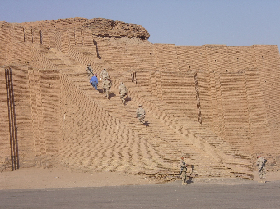
Climbing the Stairs at UR ..
War Trophy? Planting the Flag at UR ..
"We will take the Hill!" |
|||||||
|
Tallil Air Base Iraq ..
Tallil Airbase
Tallil Airbase is located approximately 310 kilometers Southeast of Baghdad and 20 kilometers Southwest of the city of An Nasiriyah. The airfield is served by two main runways measuring 12,000 and 9,700 feet. Sited on sandy desert, the base is capable of supporting at least two fighter squadrons with support units. According to the "Gulf War Air Power Survey", Tallil had 36 hardened aircraft shelters. At the each end of the main runway are hardened aircraft shelters knowns as "trapezoids" or "Yugos" which were build by Yugoslavian contractors some time prior to 1985. Tallil occupies 30 square kilometers and is protected by 22 kilometers of security perimeter. The An Nasiriyah weapons storage area is located about 7 kilometers to the East which occupies 7 square kilometers. This WSA appears on a 1985 Russian map but it is not known whether it was struck during Operation Desert Storm, or Desert Fox. - Global Security
By March 2003, Tallil AB was an air base in name only. The Iraqis had not flown aircraft out of it since 1991, when the US bombed the base during Operation Desert Storm. During OSW the airfield housed Iraqi air defense functions, was in the southern no-fly zone, and had a limited civilian presence. For all of those reasons, buildings on Tallil continued to be attacked by the US forces carrying out sanction-enforcement operations. The runways, taxiways, and ramps had not been maintained, water supplies were brought in by trucks, and a system of portable generators and batteries provided the only available electrical power. Tallil looked like what it was -- an airfield the Iraqis had lost to their enemy. However, Tallil AB did have several features to commend it for use by coalition forces: its runways were not cratered; it was located south of the Euphrates River; it was twice as close to Baghdad as was Al Jaber AB; it was along a major supply route from the south; and it was essentially isolated from any significant civilian populations. An Nasiriyah was seven miles away and on the other side of the river. The first conference between Jay Garner, the US civil administrator in Iraq, and Iraqi groups on 15 April 2003 near Ur was marked by tensions. The first, almost entirely symbolic gathering in southern Iraq when Garner met with former exiled opposition parties near the ancient ziggurat of Ur. That meeting saw all participants pledge to help rebuild the nation, clearing the way for more substantive talks to follow. - Global Security
Everything that does not move is covered in a grayish-brown, powdery dust. The heat is oppressive -- more than 120 degrees in the shade. Open fields and roads bear craters large enough to swallow small trucks. In March 2003, the area around Tallil Air Base looked more like the surface of the moon than the bustling tent city and flightline area standing today. After the base fell to coalition forces during Operation Iraqi Freedom, the landscape was desolate, except for a few abandoned buildings, many of which still had extensive damage remaining from the first Gulf War. The task of
transforming this
uninhabitable stretch of desert brushland into an
operational air base
fell on the 407th Expeditionary Civil Engineer
Squadron. In four months,
the people assigned to the unit moved more than
9,500 truckloads of fill
dirt, assembled more than 350,000 square feet of
facilities, trenched more
than 40,000 feet of electrical cable and buried
more than five miles of
underground water pipe. - Global
Security
The 64th Expeditionary Reconniassance Squadron operated Predator unmanned aerial vehicles. The Predators roam the skies of Iraq providing real-time information to commanders around the world. The famed "Red Tails" were on the move when they relocated from a base in southern Iraq to just north of Baghdad. The 332nd Air Expeditionary Wing flag was furled before being flown to its new home at Balad Air Base, where the wing was reactivated 30 January 2004. The move was part of the Central Command Air Forces effort to consolidate forces from Tallil, Baghdad International Airport and Kirkuk AB into one location. Although the wing's time at Tallil AB was short, the accomplishments of its airmen easily measured up to the wing's legacy. The men and women of the wing had been at the tip of the expeditionary airpower spear. The 332nd had been operating out of Tallil for six months. CENTAF did not completely vacate the base in southern Iraq-the 407th Air Expeditionary Group, commanded by Col. Kevin E. Williams, remained at Tallil. A small Korean force, while located at Tallil Airbase, gave medical assistance in Al Nasiriyah, as well as rebuilding a hospital with an engineering unit. They have also rebuilt a couple of schools for local children. By February 2006 the base contained a gym, a volleyball court, and a so-called morale tent complete with DVD players, books, and computers. - Global Security Read More Here
|
|||||||
|
Ziggurat at UR Middle of a War Zone
Ur, Iraq's most famous archeological site, was perhaps the earliest city in the world. Ur flourished under the Sumerians between 3500 BC and 4000 BC. It is located near Tallil, a major airbase and radar center which was bombed in the 1991 Gulf War. Ur has been identified with the birthplace of the biblical patriarch Abraham. In the early decades of the 20th century, excavations uncovered a royal cemetery in which members of the ruling elite were buried with their servants and beautifully-made possessions. Ur's dominant feature is the remains of a ramped ziggurat or temple tower, the best preserved in Iraq. In February 1991, General Horner tasked RED HORSE to deny two air bases in southeastern Iraq to prevent future use by returning Iraqi forces, and the work had to be completed before the signing of a cease fire agreement. Working with EOD personnel, two teams completed the job within four days. At Tallil AB, RED HORSE used approximately 40 tons of explosives to make cuts in the runway and taxiway every 2,000 feet. At Jalibah AB, engineers denied a concrete runway and two asphalt taxiways with 72 craters up to 40 feet wide and 12 feet deep. - Global Security |
|||||||
|
Saddam's Weapons Plant?
|
|||||||
| FAIR USE NOTICE: This page contains copyrighted material the use of which has not been specifically authorized by the copyright owner. Pegasus Research Consortium distributes this material without profit to those who have expressed a prior interest in receiving the included information for research and educational purposes. We believe this constitutes a fair use of any such copyrighted material as provided for in 17 U.S.C § 107. If you wish to use copyrighted material from this site for purposes of your own that go beyond fair use, you must obtain permission from the copyright owner. | |||||||
|
|