|
Sinkholes Assorted |
|||||||||
|
..
..
|
|||||||||
|
Wood Buffalo National Park Alberta and Northwest Territories ..
|
|||||||||
|
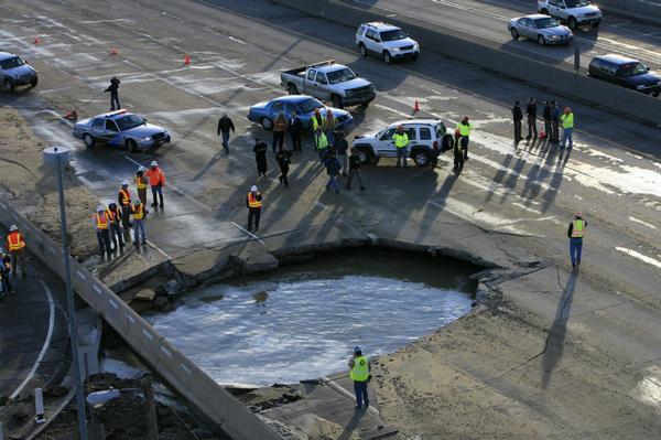
Denver, Colorado ..
Thursday
Headlines: Sinkhole Costs State DOT $1 Million
Posted in Colorado, Georgia, North Carolina, Pennsylvania, Texas at 11:59 am by bengann The Colorado Department of Transportation spent more than $1 million to repair Interstate 25 last month after a main owned by Denver Water burst and opened a 16-foot sinkhole. (photo courtesy of Rocky Mountain News) |
|||||||||
|
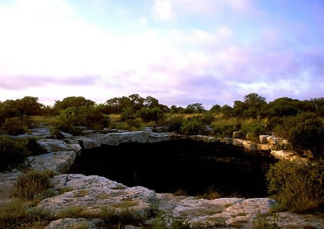
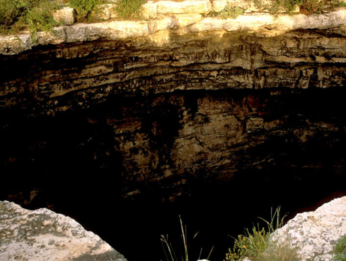
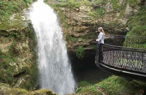
Devil's Sinkhole Rock Springs, Edwards County, Texas ..
Devil's Sinkhole The name, Devil’s Sinkhole, aptly connotes the dark depths and other-worldliness of a vast vertical chasm in the limestone bedrock on the far western reaches of the Edwards Plateau. Given it’s unique qualities, the site was undoubtedly considered a sacred place by native peoples. Although there is no evidence of it within the cavern itself, several small prehistoric campsites, including a burned rock midden, ring the wide mouth of the sinkhole. Based on the single dart point recovered there—a Pandale type, with characteristic twisted body—the site was used by campers in the Middle Archaic period, sometime between 2500 to 4000 B.C. The sparse cultural remains and features, however, probably present an inaccurate picture of what may actually have occurred there in the prehistoric past. For years, cowboys and tourists collected artifacts and even stalactites from the cave interior. Located just north of Rock Springs in Edwards County near the headwaters of Hackberry Creek, the sinkhole is a vertical cavern cutting into Edwards Limestone with an opening measuring approximately 40 x 60 feet and a vertical drop to the main cavern of about 140 feet. The main cavern is circular and reaches a total depth of 350-400 feet. Part of a vast karst system of underground caves in the porous Edwards Plateau, the sinkhole was created when an underground solution cavity collapsed. Native peoples found abundant, high quality chert for tool making at the site, one of the largest bedrock lithic resources in Texas. In much later times, the sinkhole was a gathering place for cowboys and cavers, who etched their names and other graffiti into the limestone walls. Beginning in the early 20th century, Edwards Plateau entrepreneurs began mining the sinkhole for bat guano to be processed into ammonia fertilizer. While no professional archeological investigations have been conducted within the Devil's Sinkhole itself, archeological surveys of the area surrounding the chasm have identified a total of 21 prehistoric sites spanning late Paleoindian to Historic Period times. Based on the site sizes, the nature of the artifact assemblages, and the presence of burned rock middens on some sites, we know that prehistoric people used this landscape for short-term lithic procurement stations and long-term plant processing, tool manufacture and refurbishing, and habitation sites. SOURCE: Texas Beyond History
|
|||||||||
|
Codroy Valley, Newfoundland ..
Sinkhole in the Codroy Valley. Sinkhole in the Codroy valley, western Newfoundland. Sinkholes are funnel-shaped depressions, or sinks, in the ground surface, commonly tens of metres in diameter. They are found in areas where local rock can be slowly dissolved by water (e.g. limestone, chalk, gypsum). They form when the roof of an underground cave collapses or by surface solution. |
|||||||||
|
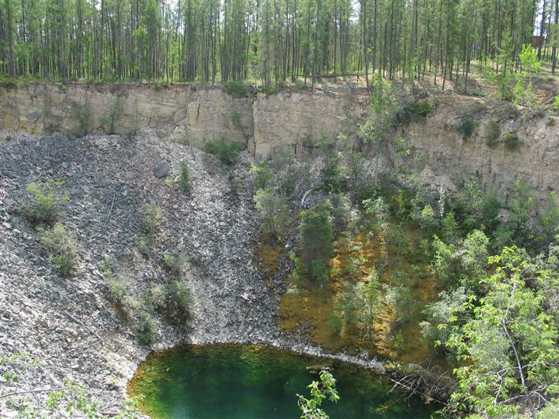
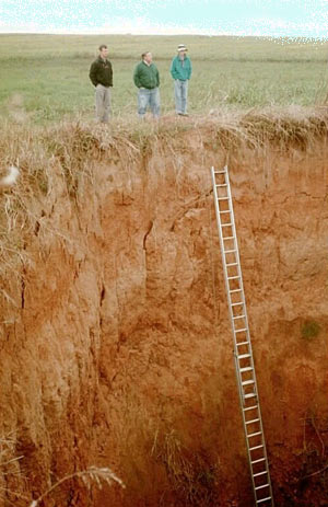
Logan County, KY ..
Sinkhole in the Logan County This sinkhole in Logan County, KY is 70 feet deep. It opened in 1997 after heavy rains. The geology here is similar to the site chosen for the Kentucky TriModal Transpark. - SOURCE |
|||||||||
|
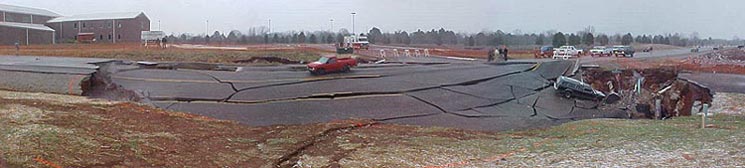
Bowling Green, KY ..
Sinkhole in Bowling Green, KY This giant sinkhole collapsed in Bowling Green, KY, just a few miles from the site of the proposed Kentucky TriModal Transpark. It is approximately 200 feet in diamater, and 35 feet deep. - SOURCE |
|||||||||
|
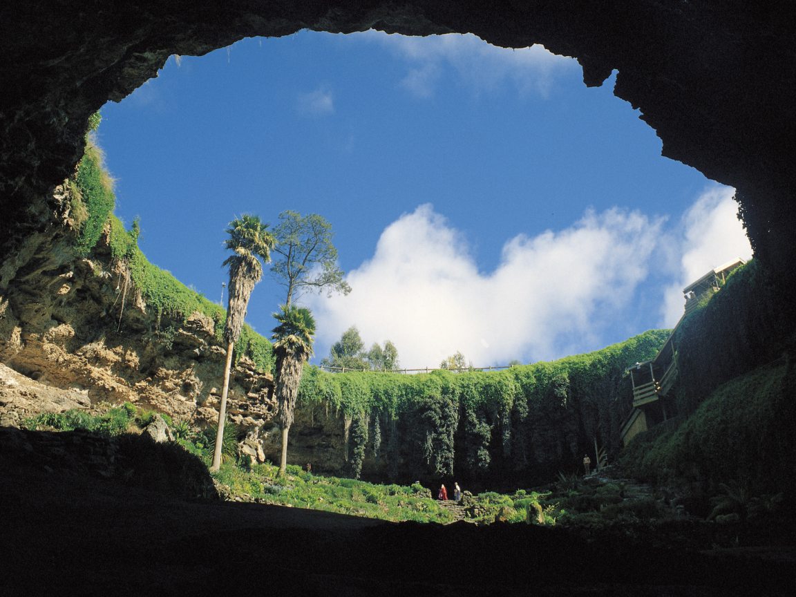
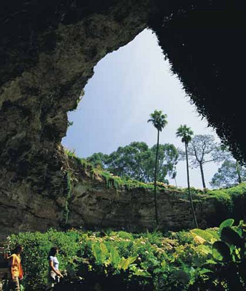
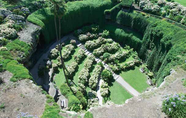
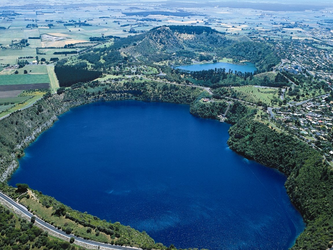
Mt Gambier, South Australia City of Craters, Lakes, Caves & Sinkholes Umpherston Sinkhole ..
..
Once a cave formed through dissolution of the limestone, this sinkhole was created when the top of the chamber fell to the floor of the cave, creating the perfect environment for its "sunken garden". Originally beautified by James Umpherston around 1886, it is open at all times, from dusk each evening the area comes alive with possums as they venture into the floodlit gardens to feed. A large undercover shelter with group seating and free BBQ is provided. Ph: 08 8724 9750 - FREE OF CHARGE ENTRY The Cave
Gardens
..
..
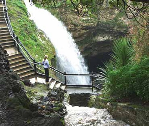
The Cave Gardens Situated in the centre of the city this sinkhole was the original source of water supply for the early settlers. Famous for its roses, the Cave Gardens is a great place for a picnic. Its beauty and significance can be appreciated from the viewing areas. Walk down into the cave and venture out onto the suspended viewing platforms for an awesome view into the cave which directs storm water run-off from the city streets down under the city where it is believed to eventually enter the underground water system. With its spectacular lighting, it is well worthwhile a visit at night. FREE OF CHARGE ENTRY. Ph: 08 87 249750 Engelbrecht
Cave
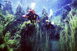
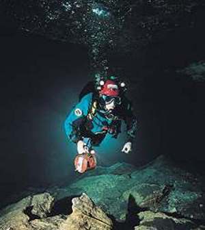
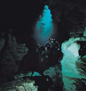
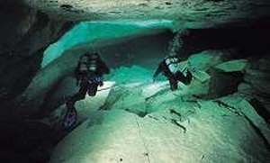
Engelbrecht Cave Tour This huge complex of limestone caves under the city was first explored around 1884. Cave divers who have undertaken intense training regularly explore this site and have provided maps showing the extent of this underground cave system. 45 minute guided tours, take visitors down into 2 of the chambers where divers enter the water to dive under the city. See how caves are formed and how the underground water filters through the tour down into two of the chambers where the divers enter the water to dive under the city. Watch a short video on cave diving. Ph: 0418 133 407 Divers come from around Australia to dive beneath the streets of Mount Gambier in Engelbrecht Cave
Engelbrecht
Cave is one of many caves beneath the streets of
Mount Gambier, but is the only one that is
accessible by divers. Tours operate daily to take
you down to see where the divers enter the water
to explore the water filled caverns. Watch a
video on how divers safely explore this huge
complex of caves. Dreamtime in the World's Clearest Water - Divernet It takes 500
years for the underground water to move through
the limestone from Blue Lake to the southern
ocean. Geological
Diagram Papers:
|
|||||||||
|
Mt Gambier, South Australia Southern Australia -36° 47' 4.35", +140° 32' 59.32" ..
..
''
Take a Google Earth tour of the Region. The whole area is literally riddled with sinkholes... but the Blue Lake clusters are certainly the most impressive. The area above is near Naracoorte Naracoorte Caves is a national park near Naracoorte in the Limestone Coast tourism region in the south-east of South Australia (Australia). It was officially recognised in 1994 for its extensive fossil record when the site was inscribed on the World Heritage List, along with Riversleigh. The park preserves 6 km² of remnant vegetation, with 26 caves contained within the 3.05 km² World Heritage Area. Naracoorte
Caves
National Park - Wikipedia
|
|||||||||
SINKHOLE INFO SITES:
|
|||||||||
| FAIR USE NOTICE: This page contains copyrighted material the use of which has not been specifically authorized by the copyright owner. Pegasus Research Consortium distributes this material without profit to those who have expressed a prior interest in receiving the included information for research and educational purposes. We believe this constitutes a fair use of any such copyrighted material as provided for in 17 U.S.C § 107. If you wish to use copyrighted material from this site for purposes of your own that go beyond fair use, you must obtain permission from the copyright owner. | |||||||||
|
|


