The Active X control is for Windows Media Player.
The file is below the player for download.
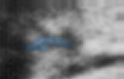
Apollo 15 Command Module Photo

AS15-94-12741HR

Take a look at the photos below first if you prefer but the text analyzes and explains what I think is in them. All off-site links as well as the images open in a new window so you can do comparisons.

This next clip is of a relatively high-res Apollo 15 photo from 119km above the Moon's surface. While waiting for the LM to return, the Command Service Module Pilot Al Worden, was doing experiments and taking more photos. (70mm Hasselblad, Mapping Metric and Panoramic) He also used hand-held 35mm SLR cameras from inside the CSM.

It looks like there are two structures similar to operations where I've worked at one time.

Other areas in the image could be related. There are two versions of this photo.

Here's the actual two versions at original resolutions from their respective sites:

NORTHEAST OF TSIOLKOVSKIY

AS15-94-12741
(13Kb JPG)
AS15-94-12741
(90Kb JPG)
AS15-94-12741HR
(1.08Mb JPG)

Sources

NASA - Apollo Image Gallery - Apollo 15 (med & hi res)

LPI - Apollo Image Atlas - Magazine S (low res)

This is a very low-res version. All the photos in this magazine were scanned at lo-res. and there isn't any real detail in any of them.
 

...
...
...
The Reason I Think These Are Structures In AS15-94-12741HR

They seem to have straight-line 3D symmetrical shape in a configuration I'm familiar with. Shadows and shading are consistent with the images light direction. The outer edges of these "structures" conform to the surface terrain around them. The left structure's north end looks like there's industrial pipelines going into the ground.

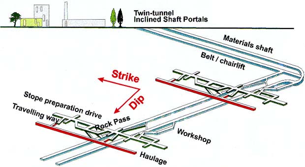
The resemblance of NASA and other industries designs is very close. (comparison below) I was employed in the early 70's at an underground mining operation in NT, Australia that had a similar type of surface-to-subterranean layout. We used underground to surface conveying systems, protected within the pipelines.

Other shafts and pipelines contained access and personnel corridors, equipment transport and side-connected tubes for workshops, engineering offices and break-rooms. Self contained, climate controlled and some large enough to drive through.
 

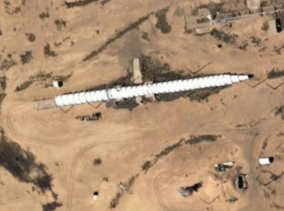
Much like these underground and in-mountain inserts and connectors, being constructed at
Kirtland AFB for the Manzano Weapons Storage Facility located there. (Note they're big enough to drive into and these are small ones) The longer one shows the blast doors installed and the left end is open.

See the huge crane under the camouflage netting?

After verifying all the components fit properly, it's disconnected in smaller sections for transport. Then depending on the underground configuration, "T" and /or "Y" connectors
are attached to branch off into other tubes. And for everybody's information, these are also used for access and expansion of existing underground bases that I guarantee you, do exist.

(I have place marks at these in Google Earth titled: Large Tube & Larger Tube)

Kirtland AFB

 
370ft Long Tube Under Construction
(click image for larger view)
830ft Long Tube Under Construction
(click image for larger view)

Pegasus Addition:

Many people have asked us how can they hide things, especially since Google Earth can see everywhere. Discounting the fact that Google Earth can easily be edited ( I am sure there are sensitive areas in the world the government will not let them look at) here Jack has found clear visual proof of just how easy it is 
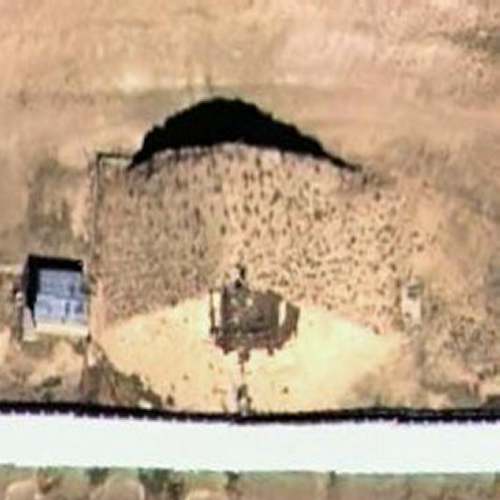
to hide things from space cameras. Below you will see camouflage netting that has been only partially deployed and you can see a huge machime, bigger than buildings on the site, partially hidden. Notice the texture of the tent... if it was complete, it would look like a piece of natural terrain. It is noteworthy at this point to mention that Guy Cramer, one of the three people who own most of the mineral rights on the moon owns HyperStealth Biotechnology Corp a company that specializes in camouflaging large structures. One of their contracts is the H.A.R.R.P facility in Alaska.

So if we are assuming that they are hiding things from us on the Moon and Mars, you can see how much more difficult it is finding anomalies, never mind any editting or touch up on photos afterwards.
 

Closeup of camouflage netting at Kirtland AFB
Image Courtesy Guy Cramer
Compressor with current monotone color
Image Courtesy Guy Cramer
 Compressor with Tumbleweed-6A-100 camouflage paint
More samples on this page by Guy Cramer H.A.R.R.P
...
...
...
Back to the photo...

My Theory On What They May Be

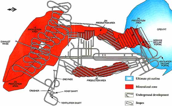
Underground Mining and Processing Sites. Along with habitat and laboratory modules. And possibly support sites in the near areas.

Before you call the nearest institution on me, consider this... The caption in the version from the Apollo site reads: "Lunar Orbit View: Lobate Landslip Outside Northeastern Rim Of Tsiolkovsky" The landslide debris is the "chunky" area at bottom left in the photo. What better mining conditions when you have a massive section of wall several miles wide and hundreds of feet high already collapsed?

On one of the largest ejecta blankets on the planet....(more on that below) And Tsiolkovsky is considered one of the more recent impact craters, in geological time.

The first site is just above the bulk of the rubble. The second site looks to be 3 to 5 miles to the east in this images orientation. Because of the Command Orbiter's flight path, east is actually NNW in the Hi-Res photo. The scaled image width of the photo is approximately 15 miles.
 

So what's being mined?

Any number of minerals and elements. Titanium, Helium3, Regolith, Gold and possibly elements or minerals that don't exist on Earth.

And oxygen!

Scientists and astronomers have already confirmed that craters are disappearing from the surface. Past large impacts splattered sub-surface material and what's left of the meteor, asteroid or comet in what's called ejecta all around the newly formed crater. Astronauts brought back crater ejecta full of oxygen. It makes sense that this can be mined and stored in underground silos or containment vessels for later use.

Pegasus Note:
See LPI document 6034.pdf This document is about ISRU mining of Lunar dust and regolith to produce glass from Solar furnaces to make fiberglass stuctures on the Moon. As a byproduct of this glass making process they get iron oxide and titanium oxide, AND free oxygen to use for breathing and making rocket fuel (liquid oxygen)

The term ISRU is something you need to get famliar with... it means In Situ Resource Utilization... in otherwords what IS on the Moon , STAYS on the Moon..

...
...
...
The following is an excerpt from;

The NASA Moon Photos

My Story of dealing with NASA in the 1970's

by Vito Saccheri

"In 1980, another puzzle piece fell into place. A friend had shown me a special congressional subcommittee report on moon rocks brought back by the astronauts and a feasibility study on colonizing the moon. The document was dated 1972 or `73 and concluded that moon colonization using giant plastic air bubbles was unrealistic and that we would need to transport air from the earth. The congressional report concluded that there was plenty of oxygen on the moon trapped in the rocks. The recommended solution: pulverize the rocks on a large scale with major excavations. The liberated oxygen would be stored in underground caverns and tunnel systems and the debris from these pulverized rocks dumped into the existing craters. Naturally, the craters would eventually disappear, an observation made by astronomers long before the first moon landings and, ironically, one that had initially prompted Leonard and other scientists of the 1950s to analyze early moon photos".

My Story of dealing with NASA in the 1970's
 

More information if you can find it:

"Somebody Else Is on the Moon"

written by a former NASA scientist, George H. Leonard. Leonard had been working in the photo intelligence division of NASA. My note: Why would NASA have the need for a photo intelligence division? I can think of only one reason....they have photos they don't want us to see. I have seen this book (paperback version) and it doesn't show anything in the grainy photos that he sees but the info in it is interesting.

...
...
...
OK...enough of my, "You must be nuts" theory.

However, not one person in the scientific community or NASA circles has explained to me in any uncertain terms as to what these shapes are! So I'm allowed. One more point. Now the question is...

Who is doing the mining?

Well...if astronomers have been watching craters disappear long before we sent our first Moon landing....?

And then there's these... Operations in progress today...
 

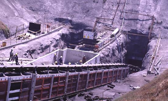
One of the Atlas Copco rigs emerging from the new incline shaft.

The following is the text for these two photos:

#1: "Gloria "(shaft name) combined a vertical shaft for personnel and materials hoisting with a long incline shaft for vehicle access and conveyor hoisting of the ore to a surface crushing, screening and washing plant".

 "The new expansion follows this design, having a 2,200m-long incline shaft and the 500m-deep No.3 personnel shaft. There is also a new ventilation shaft, and a workshop located on the 400 level".

#2:For the new area, Assmang requested a three-boom rig fitted with two rock drills for face work plus one for roof-bolting, so the mine can drill holes for roof bolts and face-blast holes from the same set-up. Atlas Copco has supplied four purpose-designed Rocket Boomer M3D rigs.

Source: Assmang Manganese Mines, South Africa
 

Typical Sub-Layout 
Complex Layout
(Click images for larger views)
Other types of openings and surface layouts

Pegasus Addition:

In Copernicus Crater (See The Living Moon pages) we found evidence of just such a tube structure... The  resolution on the copy of LO-III-162 that we have from an original unretouched 16x20 negative is extremely high res, but because of the scale objects are still difficult to find....
 

Tube Enlarged from Original High Res Image
Tube Highlighted to show detail. The tube comes out of a dark hole and bends, clearly showing a support. This Tube is in an area that shows other structures consitant with a mining operation
(See The Living Moon)
Tube sketch. The visible features of the tube in this image
Tube from existing Mine on Earth
...
...
...
Getting back to the photo again...

The reflectivity of the shapes are consistent with other areas in the image and not overly over-exposed. It can be determined the shapes are in the photo and not on the glass or negative by analyzing the focal point. If on the glass or negative, after being re-photographed and later scanned, the shapes would be over exposed into a "blooming" effect, giving the edges and the bulk of the shapes a bright Gaussian type blur. Much brighter than the images brightest feature. The focal point being the surface terrain, shows these objects consistency of pixilation with the area around them when enlarged.

Debris on the glass or negative would pixilate at different levels. And if debris, it would be closer to the scanning light than the subject being scanned, making them blurrier and brighter. And here's something everyone should know. Like most new technologies, scanners were available to the military long before they became available to the public. Although most were re-photographed in smaller sections from the large mosaics into 16x20 prints.

The AS15-94-12741 photo is not from a mosaic, it was taken with the 70mm Hasselblad. You'll see what looks like hair or fibers in the scanned Hi Res photo. On closer inspection, they are actually rilles and channels created by smaller impacts in the area. I first thought the shapes were common errors created from debris on the scanner glass or an anomaly in the negative until I enlarged it and took a closer look at the two shapes that are visible without enlargement. Some of the smaller specks, smudges and dark lines scattered around this image, are probably from the scanner glass, on the camera window or negative itself.

Why I Think The Shapes Are Not Scanning Or Other Errors

On the Lunar and Planetary Institute(LPI) site, there are dozens of mosaics (of the Lunar Orbiter images) that have developing and scanning errors. Some are caused by developing solutions drying on the negatives. Some are oily fingerprints transferred to the negatives. Others have sticky-tape residue on them.

I'm sure cosmic radiation had a hand in creating film anomalies.

Some look like an airman spilled beer on them. (Karl Wolfe)?

Others show tape or clips that were used to hold the

print strips in place when creating mosaics.

And numerous other causes.


But most of them are dried condensation on the negatives and prints from poor

storage practices before and after the mosaics were created.

When scanned in visible light scanners, these errors get

overexposed and create the blurry patterns.

But it's hard to tell which came first, photos that were scanned then re-photographed...

or re-photographed prints that were scanned and then digitally re-photographed.

It really doesn't matter, the fact that they have these errors is the point.


And I've seen some web sites that claim these patterns are bases. They are not.

It's too bad some people manipulate photos to "enhance" the area.

And when it doesn't look quite real enough, all boundaries are crossed

in the name of sensationalism and authenticity. And no matter

how many sets of letters are behind someone's name, detail can't be created

by making it bigger than it was meant to be viewed.

If the original photo doesn't show any detail at just 100%, there isn't any!

The more you enlarge any photo,

the less detail you have and more pixilation at the same time, resulting

in shapes seemingly taking on transmutations but usually with some help. The same goes for

hi-res scans of lo-res photo negatives.


Even in this hi-res scanned photo I found. In fact, I've removed all the enlargements

I've made on other pages because they really don't bring out any detail, just larger pixels.

(with the exception of the Wisps and the circular object which are only 2x enlargement)

But this AS15 photo does show detail at just 100%

so enlarging it doesn't alter its shape or form.

And everyone should know, I'm not claiming anything in these pages, and haven't.

Just sharing my observations, theories and experiences as well as knowledge on photography and optics.

There is only two ways to confirm what's real or not...

The authority that created it comes forward with all the data or

we go there ourselves.........I'll volunteer.


In another section below, I've include a few to show you what these common and uncommon errors look like.

You'll see that the errors extend into space, well away from the surface and some, off the edge of the negative itself.

(These web sites don't show you that part)

You'll agree they all are completely different from the two shapes in this photo.

I have looked at every photo (thousands) on these two sites over the years

and there isn't one other photo with the same shapes as in AS15-94-12741HR.

If anyone has, I would like to know the photo # please.


One more note: I was so intrigued with this photo I emailed the authority

 that scans the negatives in a very high resolution .tif format for the public. (57Mb).

http://www.lpi.usra.edu/library/rpif.shtml

...
...
...
...
...
...
...
...
...
...
...
...
...
...
...


When it's ready, assuming they have the requested negative, they send you an email with a web site to download it from.

(In my case it took only one day before I was notified)

I was really excited while I waited for it to download. Then reality. It looks like a blown up copy of the lo-res version.

Nothing in it. Not even the smaller impact signs. And it was so dark that when I lightened it up,

it barely looks like the same photo.

So I won't post it here, it's not worth taking up my space.

Just blow up the lo-res version to 57Mbs and you'll have the same thing.

Or you can request it yourself from the above link.

(Here's a tip: They want to know what you're going to do with the images....I'm sure for copyright concerns.

"Research on... or for...." is the correct answer...you fill in the rest)

Knowing optics and techniques of developing, scanning and photo analysis, the scanned negative

  image made for me looks to be altered. Or at the very least, scanned at lo-res then enlarged.


Here's the actual two versions at original resolutions from their respective sites:


                                                                    AS15-94-12741HR (1.08Mb JPG)                    12741 (13Kb JPG)

                                                                           From apolloarchive.com            Lo-Res version from Lunar Orbiter site


     4x enlargement of natural and color sharpened

                                                          97Kb JPG       48Kb JPG                                                                            106Kb JPG      86Kb JPG

                                   The west site's north end not only looks like                                           And what about what looks like a large cylinder in

                                       it has pipelines going into the ground,                                                         the lower area at this east site.....a TBM?

                                          it has a "cut-out" above it's center.                                              Notice the top end of it is a little wider than the rest of it.

                                At our processing site we also had a 50ft deep,                                                         Exactly like the two TBM's below.

                         100ft wide trench, 200ft long where waste material was                              And to me it looks like there's a jointed boom attached to it.

                        dumped then loaders filled trucks to haul away and bury.


I'm not suggesting the material is being trucked-out.

But if this kind of technology was in place back then,

there would be technology for a kind of lunar transporter too.

Whether it be on wheels or having flight capabilities or possibly both.

Or how about a deeper trench, reinforced on the inside to prevent collapse?

That "slot", is darker than the surrounding area.

If the waste material is being relocated somehow, we should all be checking

old and new photos of the surrounding areas of

Tsiolkovsky for smaller insignificant craters, to see if any have filled up.


A design from the early 70's.

This type is expandable to any configuration.

The similarity of the components to the east site is astounding.

And the scale of the TBM-looking cylinder is correct.

70Kb JPG


                                                                                        70's model but '82 photo

                                                                                             Well, well, look who

                                                                                                  owns this one          60's model

Although it's been suspected nuclear powered TBM's

would do the job by melting the material and fusing it

to the inner walls as it passes, eliminating the

need for underground tube inserts. I haven't found

any photos of one though. But I'm willing to bet

fission powered TBM's do exist.

TBM's are remarkable machines so here's a few more variations.


I think my dentist had a hand

in developing this.

Called a Roadheader for grinding and reaming ore from

access tunnels.

This is called a Raise Borer

used for connecting two shafts.


A reamer with adjustable jaws.


45 feet in diameter.


I highlighted in yellow other areas of suspicion

It seems logical there would be support sites.

We had them at the remote location in Australia for exploratory teams,

logistics support sites, security, transportation and local resident personnel.

So I looked even closer. I can't believe what I'm seeing.

Although these other areas are very small, some have a little detail.

                                          1.1Mb JPG


I made this context image for easy location outside Tsiolkovsky.

It took some time having only the above photo for reference.

Like the shapes, the landslide rubble has a unique pattern also.

That's what I looked for and eventually found it's location.

It's about a twenty five mile diameter sink-hole.

Now we know what a "Lobate Landslip" is.

If they had said, "a sink-hole outside Tsiolkovsky", I

would have found it in a second instead of the two hours trying to locate it.

Lobate is not a term used in mining or any other profession

with the exception of medical which it's used for describing the lobes or

condition of...according to Webster's.


                                                                                                 Context                                                          Original

  1.18Mb JPG                                                   1.14Mb JPG


Modern space exploration has given NASA and the scientific community a new and

confusing vocabulary. Most of the new terminology they use are derivatives of foreign languages.

Which makes them even more confusing if you happen to know those languages.

Another little frustrating effect this has on me is...

Just because the Moon is a foreign planet doesn't mean we have to give all it's features foreign names.

Craters and features named after people is fine but the rest is

Greek, Latin, Roman, Biblical and about a dozen others.

I think I'll create a Moon map with all English words.


An AVI Version Implicating A Certain Organization.

This is one of the flight path revolutions and photos from Apollo 15's approach to the area.

What's interesting to me is... they were interested enough to take this HiRes photo of the sink-hole.

(although I'm sure Commander Worden wasn't watching the surface all the time. He was busy with other experiments

and had scheduled duties to perform) Also, I don't know if the cameras were taking photos automatically or manually.

And then eventually this photo was chosen to be posted at the Apollo archive.

But no others of the surrounding area. That could suggest they didn't want to hide it.

 I've also noticed the Apollo archive hasn't posted any other photos showing clear errors.

The way the archive is set up, they have the photos in close sequence in each missions time frame with what looks like

selected photos that would fit within that time frame. So....they were able to be selective in what was posted.

So why would they post only one that has errors in it and not mention that little fact?

Or why didn't they select the next or previous sequential photo?

The AS15 photo was taken with the 70mm Hasselblad which has a 5 inch wide negative.

The prints this can produce and still be clear is more than half the size of your average poster.

But they most likely used 16x20 or the largest at 20x24 prints for ease of search. Someone had to see this.

Another odd note is...on the Lunar Orbiter site, the previous sequential photo, #12740 is the same photo rotated.

What's at the lower end of this sink-hole?

I haven't been able to locate any other photos around this area of Tsiolkovsky from this AS15 group.

Except for the group from the Lunar Orbiter site which are all lo-res.

And the wider-angle mapping metric high altitude passes.

After my experiences with the scanning authority,

I want to find another source.

They probably do exist but they aren't readily available

online, unless you want to trust the above library.

And there are other agencies that have copies.


The video below is the mapping metric photos as is the context image.

These are beautifully clear and free of any anomalies.

And this is the only video on my site that I do recommend viewing in full screen.

Because the video is mostly hi-res photos.


Tsiolkovsky's Secret

HiRes


-------------------------------------------------------------------------------------------------------------------------------------


A little bonus I found in Tsiolkovsky. On the mountain inside the crater, there's a "Face of Kong".

I realize it's a natural geo-formation but thought it amusing none the less.

It retains its formation in all revolutions of the CSM no matter what the angle or shading.

I find that fact interesting. In some it actually looks like it has eyes.

I found about 15 images of these fly-overs where you can clearly see the face.

Here's 5 from progressive revolutions at different angles.


http://www.lpi.usra.edu/resources/apollo/catalog/metric/mission/?15

Match the four digit number in the files with the revolution magazine.

Full image and close-ups.

Full images are 3Mb JPG's and close-ups are less than 1Mb.


Another observation:

Apollo 17 took the same flight paths in revolution numbers 62, 66 and 74.

http://www.lpi.usra.edu/resources/apollo/catalog/metric/mission/?17

Why? With all the missions combined, including Clementine, the Lunar Orbiters, Rangers and Russian, only 20% of the Moons surface was

photographed with hi-res close ups. Wouldn't it make more sense to take a different path for more coverage?

That also tells me there's something there of great interest.

There are two more posted 70mm Hasselblad photos of the sink-hole from Apollo 17 but from farther away on their approach and low-oblique.

There are no more posted from directly above as in the AS15 photo.

_________________________________________________________________________________________________________________________________


Here Are Some Photos With Condensation Marks, Fingerprints And Other Errors.

 And some manipulated photos.

Five of these show the errors extend beyond the image.

                                                                                                                                                               Large .tif (5.8Mb)


             Tape or clip.                The Most Blatantly Faked Photo Ever!                  This has also been claimed

         It probably registered in           This has been cropped, rotated, blurred,                  to be a base. Looks like a

       scanned photo as white and         greyscaled and lied about for decades.                 chewed-up ring gear on a fly-

     was darkened so it didn't stick          Don't believe me? Click on it for                    wheel. Look at the whole image.

                   out as bad.                           the original. Then check this link.

                                                                             From Apollo 16: AS16-120-19238


You can find 3 or 4 more of these

in the Apollo 17 mapping metric section.

In these you can see the Scotch tape dispenser type cutting edge pattern.

Why these were posted is anybody's guess. Possibly to show us

mistakes were made. But they look like the end of a roll.

Here's the Introduction document that tells you about

the imperfections in the Lunar Orbiter photos.

Scroll half way down to the section titled: Imperfections

It does include an explanation for condensation on the camera window but not on the photos themselves.

http://www.lpi.usra.edu/resources/lunar_orbiter/book/introduction.shtml

--------------------------------------------------------------------------------------------------------------------------------------------------------------------------

                                                                 Original

                                                                                                              (467Kb) JPG                                 (528Kb) JPG


The above photo is about the "tower" at the top of the image.

This mosaic of Copernicus has been misinterpreted and lied about for decades also.

This is from one of the Lunar Orbiter mosaics.

It’s made up of numerous print strips that are taped to hold the strips in place.

These weren’t imaging experts doing this, they were airmen doing a job they were assigned to either

because they had some photography experience before the service or were trained in this field by the AF.

And remember, this was the 60’s and early 70’s analog technologies that were in place.

High-end scanners weren't available to the military until 1973.

And they were not negative scanners. These "high-end" scanners were hand-held photoelectric cells on a wand that took a

steady hand to perfect a good scan. And the entire cell array was only six inches long and one and a half inches wide.

But early film drum scanners were the choice of scanners. Updated and much faster ones are still used today.

And only about 10% of the photos were scanned with these new instruments.

Mistakes were either overlooked or half-hearted attempts were made to correct them. This image is a good example.

After the mosaics were completed, they were stored after copies were made.


The large mosaics were photographed again but in sections that created 16x20 prints.

These sections were for ease of study and handling.

On the Lunar Orbiter web site, these prints were re-photographed yet again using an

Olympus D600L digital camera, with any errors in them or not.


One can immediately see the degradation in the image from numerous attempts to sharpen it up.

There are much better versions of Copernicus. And they're 70mm Hasselblad, not numerous strips taped together.

Want to see a couple? AS17-151-23260AS17-151-23265

But some dimwits have convinced talk show hosts and publishers, that only care about ratings and sales,

 into thinking these errors are something else.


This version has been rejoined at the vertical splices, re-photographed in a smaller size and

scanned in a higher resolution this time. And done poorly.

How do I know this? Because this image was originally featured on NASA's site as, "Photo of the Century" as

PIA00094.bmp....a common scanning format. Why this was done I don't know.

They should have used one of the AS17 images above.

The vertical joins have gaps in them that when scanned, light escapes through the

gaps and create a bright spot in the shape of the gap.

These insets I overlaid into the photo show how they tried to correct that by darkening the areas.

They are in the same vertical line as the "tower" at the top. And that thing doesn't

look anything like a tower anyway. It looks more like the alien in "Independence Day" than a tower.

And if you look at the top of it, you'll see a broken and dashed white line going straight left across the images

outer space area. This is the last upper most strip that was joined with a space background image

or just a black color panel to give the illusion of space. You see this in the .bmp first version.

The .jpg version has been "cleaned up" a bit more.

I’m sure they didn’t attempt to correct that white spot at the top because of its location and

probably wasn’t considered an area that would be under study because of its extreme

distance in the background. And there are clearer photos of that area as well at higher resolutions.

That area is the mountainous region of Montes Carpatus NW of Copernicus.

If you look at the original image and check the placement of the other vertical lines, you’ll see a few more of these.

The horizontal lines are where the original joins meet that made up the entire mosaic. And may have

had gaps at those junctions as well.


------------------------------------------------------------------------------------------------------------------------------------------------------------------------


                                                     These triangles are indexing marks in the camera. Some have been darkened, most are white

                                                              and some have been manipulated to make you think they are something else.

                                        I thought they were in my context image of Tsiolkovsky. But after checking the next and previous photos,

they show only one black triangle also. It's a piece of debris on the camera window.


I believe they are adjustable in width for reference, depending on the application.

I couldn't find a description on these in the camera information but I've seen these before.

And they were in photos taken on Earth.

Ones that seem to cross the join lines of the mosaics below are because of blooming.


    When you click this one,                                                                                                                   Near top of image                          Top of image

           it's the original.

    A UFO & base claim on the

            Comments page.


__________________________________________________________________________________________________


Time for more levity.

NASCAR on the Moon

THE TSIOLKOVSKY 500

Actually, I have no idea where this feature

is located but since this page deals with Tsiolkovsky....

Update:

This feature's name is Wallace, (Hey, an English name)

located in lower right section of Mare Imbrium, directly above Sinus Aestuum.

A little NE of Copernicus.

So I guess it should be called "The Wallace 500"...

....nahh, Tsiolkovsky has more pizzazz. And we have Rusty, Kenny, Mike and Steve already.

By the way, this is the Russian physicist Konstantin, the father of modern rocketry, (before Braun)

and not the composer, Peter Tchaikovsky. Spelling is slightly different but pronounced the same I believe.

Another note is the Lunar Orbiter site mistakenly spells his last name with an "i" before the y.
 

I rotated both photos 90° for better orientation.


                                                                                           1Mb JPG's                         Night racing too!

                Back To Moon Index                                                                                                                                            Next Page

Boomslanger.com


Watch The Moon Closely

Facts Are The Only Truth


   All content created by boomslanger.com © is not for public use and distribution.   Please don't abuse it.
  Or I'll send Hillary to get you. |||||||||||||||||||||||||||||||||||||||||| All content has embedded codes anyway.