|
|
||||||||
|
16º 33' 20.22" S, 68º 40' 20.64" W ..
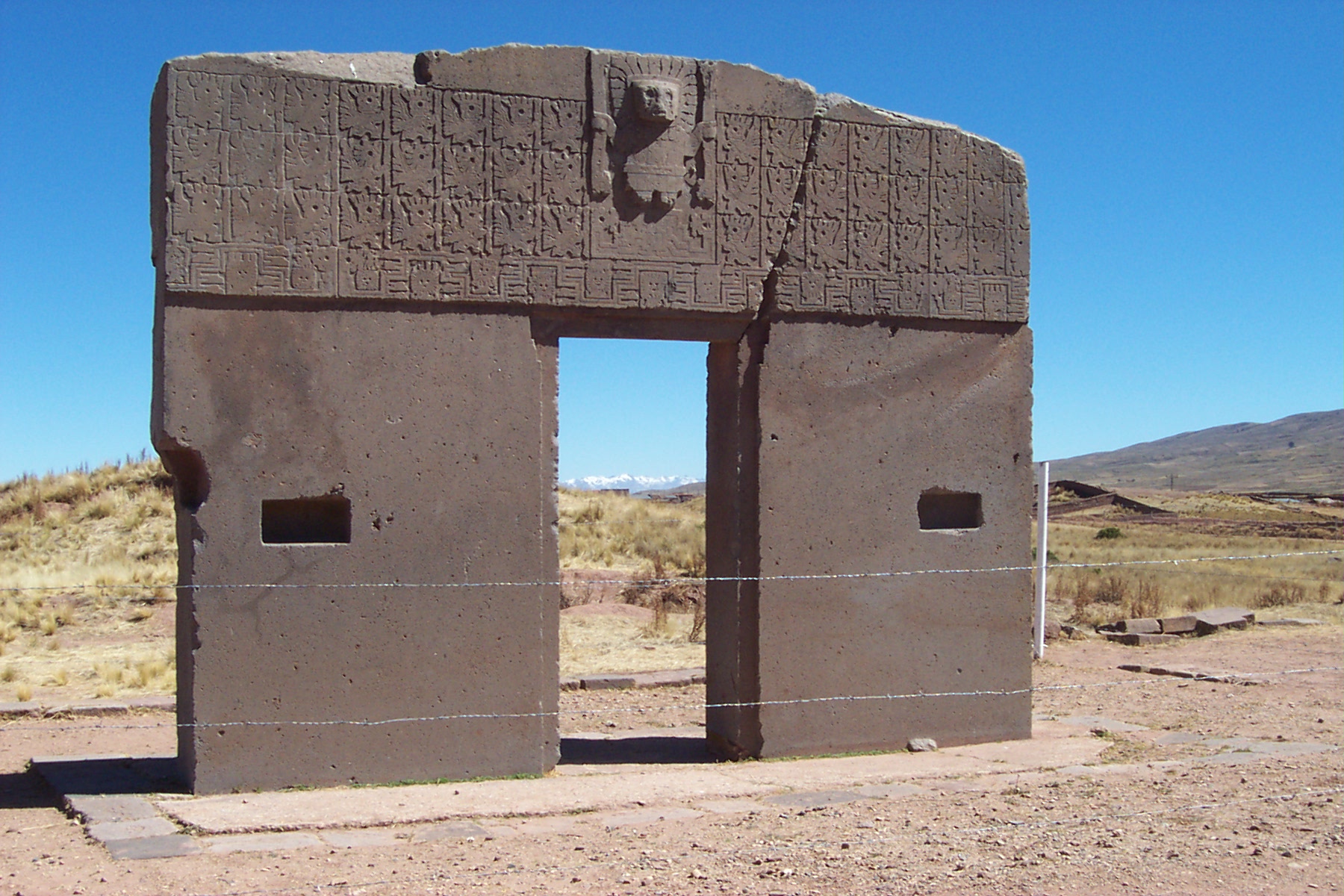
A little background... Tiwanaku Tiwanaku, (Spanish: Tiahuanaco and Tiahuanacu) is an important Pre-Columbian archaeological site in western Bolivia, South America. Tiwanaku is recognized by Andean scholars as one of the most important precursors to the Inca Empire, flourishing as the ritual and administrative capital of a major state power for approximately five hundred years. The ruins of the ancient city state are near the south-eastern shore of Lake Titicaca in the La Paz Department, Ingavi Province, Tiwanaku Municipality, about 72 km (45 mi) west of La Paz. The site was first recorded in written history by Spanish conquistador and self-acclaimed "first chronicler of the Indies" Pedro Cieza de León. Leon stumbled upon the remains of Tiwanaku in 1549 while searching for the Inca capital Qullasuyu. Some have hypothesized that Tiwanaku's modern name is related to the Aymara term taypiqala, meaning "stone in the center", alluding to the belief that it lay at the center of the world. However, the name by which Tiwanaku was known to its inhabitants may have been lost, as the people of Tiwanaku had no written language Source: Tiwanaku Wikipedia |
||||||||
|
..
..
..
..
In the holograms of reality, Tiwanaku is another ancient civilization whose timeline came and went, leaving behind megalithic monuments that go without explanation as to their mathematical design and construction. Considered by some the oldest city in the world, much of Tiwanaku's creation defies the laws of physics and mathematics even by today's standards. Many monuments bear close resemblance to those created by other ancient cultures all over the planet, truly an overlap if one were to place hologram over hologram, to define the journey of humanity in time. As with many other sacred sites throughout the planet Tiwanaku remains an enigma allowing researchers to speculate on its origins and purpose then parallel that with other ancient civilizations left behind by unknown beings surviving in time with great stone markers which bear clues to humanity's creation story. Gods, temples, idols, metaphors, all clues in a puzzle humanity is unraveling at this time of conscious awakening. Source: Crystal Links Some believe Tiwanaku is the oldest city in the world. Others believe it was built by an extraterrestrial race who also created the Nazca Lines.
The area around Tiwanaku may have been inhabited as early as 1500 BC as a small agriculturally-based village. Most research, though, is based around the Tiwanaku IV and V periods between AD 300 and AD 1000, during which Tiwanaku grew significantly in power. During the time period between 300 BC and AD 300 Tiwanaku is thought to have been a moral and cosmological center to which many people made pilgrimages. The ideas of cosmological prestige are the precursors to Tiwanaku's powerful empire. TiwanakuÕs location between the lake and dry highlands provided key resources of fish, wild birds, plants, and herding grounds for camelidae, particularly llamas. The Titicaca Basin is the most productive environment in the area with predictable and abundant rainfall, which the Tiwanaku culture learned to harness and use in their farming. As one goes further east, the Altiplano is an area of very dry arid land. The high altitude Titicaca Basin required the development of a distinctive farming technique known as "flooded-raised field" agriculture (suka kollus). They comprised a significant percentage of the agriculture in the region, along with irrigated fields, pasture, terraced fields and qochas (artificial ponds) farming. Artificially raised planting mounds are separated by shallow canals filled with water. The canals supply moisture for growing crops, but they also absorb heat from solar radiation during the day. This heat is gradually emitted during the bitterly cold nights that often produce frost, endemic to the region, providing thermal insulation. Traces of landscape management were also found in the Llanos de Moxos region (Amazonian food plains of the Moxos). Over time, the canals also were used to farm edible fish, and the resulting canal sludge was dredged for fertilizer. The fields grew to cover nearly the entire surface of the lake and although they were not uniform in size or shape, all had the same primary function. Though labor-intensive, suka kollus produce impressive yields. While traditional agriculture in the region typically yields 2.4 metric tons of potatoes per hectare, and modern agriculture (with artificial fertilizers and pesticides) yields about 14.5 metric tons per hectare, suka kollu agriculture yields an average of 21 tons per hectare. Significantly, the experimental fields recreated in the 1980s by University of Chicago's Alan Kolata and Oswaldo Rivera suffered only a 10% decrease in production following a 1988 freeze that killed 70-90% of the rest of the region's production. This kind of protection against killing frosts in an agrarian civilization is an invaluable asset. For these reasons, the importance of suka kollus cannot be overstated. As the population grew occupational niches were created where each member of the society knew how to do their job and relied on the elites of the empire to provide all of the commoners with all the resources that would fulfill their needs. Little is known of the 30,000 to 60,000 urban dwellers or of the city's crafts or administrative functions. We also know little about the storage system that was required for the bounty of surplus foods from the agricultural fields, the vast llama herds on the Poona, and the abundant fish caught in the lake. The core of this imperial capital was surrounded by a moat that restricted access to the temples and areas frequented by royalty. Some occupations include agriculturists, herders, pastoralists, etc. Along with this separation of occupations, there was also a hierarchal stratification within the empire. The elite of Tiwanaku lived inside four walls that were surrounded by a moat. This moat, some believe, was to create the image of a sacred island. Inside the walls there were many images of human origin that only the elites were privileged to, despite the fact that images represent the beginning of all humans not only the elite. Commoners may have only ever entered this structure for ceremonial purposes since it was home to the holiest of shrines. Source: Crystal Links
..
..
|
||||||||
| FAIR USE NOTICE: This page contains copyrighted material the use of which has not been specifically authorized by the copyright owner. Pegasus Research Consortium distributes this material without profit to those who have expressed a prior interest in receiving the included information for research and educational purposes. We believe this constitutes a fair use of any such copyrighted material as provided for in 17 U.S.C § 107. If you wish to use copyrighted material from this site for purposes of your own that go beyond fair use, you must obtain permission from the copyright owner. | ||||||||
|
|
