
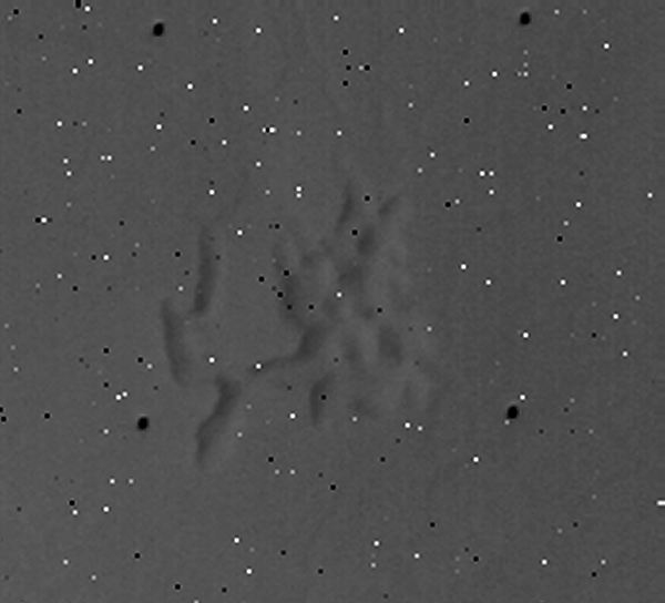
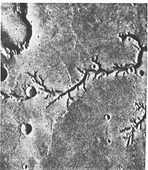
This object is named in many books and other publications as "Airport-Terminal". Not one of those sources shows the correct image ID# for finding the original data in the NASA-archives. The best reference is from David Hatcher Childress' book Extraterrestrial Archeology, where the coordinates are given: 1.9°S 186.4°W and the image-ID 4209-75.
This image-ID is not used by NASA (anymore?) and so I had to search the data by coordinates. After a short search in February 2001, I found the correct image:
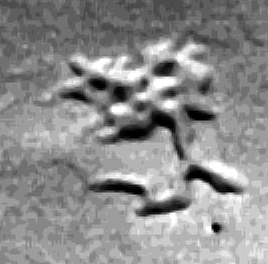
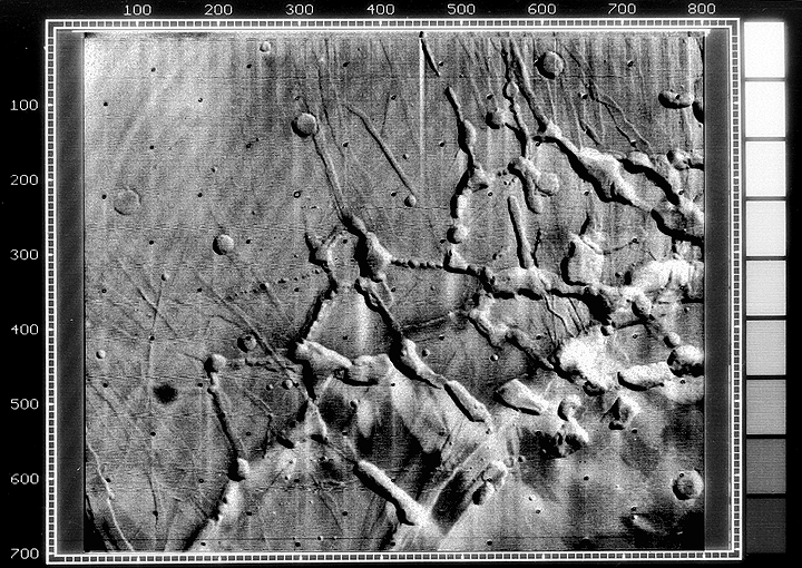
Note, that the object is not a group of mesas rising out of the plains, as it is described in the sources named above. It is a system of trenches in an area over about 5 x 5 km2. The whole original image streches over an area of exact 55 x 42 km2.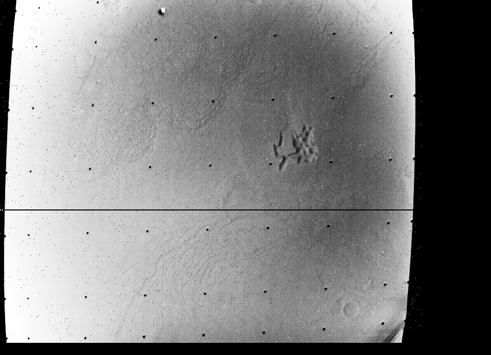 |
Credit: NASA/JPL-Cal
..
 |
..
 |
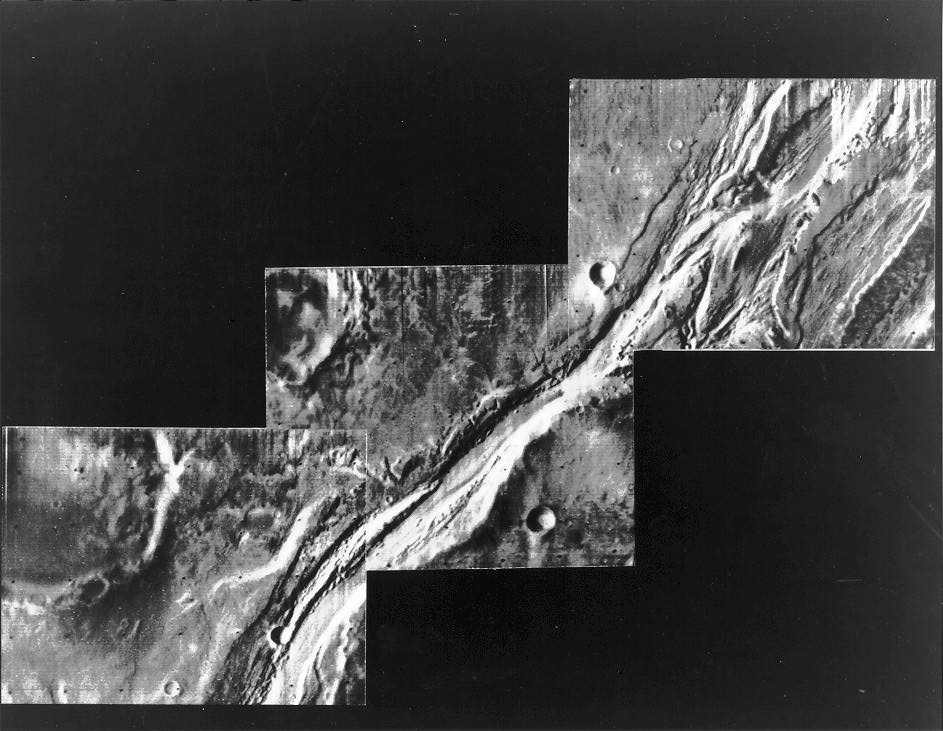
If you now say, that all socalled anomalous objects on Mars are just natural eroded hills or cracks, than you haven't seen this 500 meter long trench:
Some technical data about the "4209-75" image, the complete EDR Image Record:
177B1732 05450 AREA CONTAIN CRACKS OF MANY SHAPES AND SIZES B35 (RAA Text Describing Image)
| 1 | INST_NUM Instrument Number |
| 1972 | MTYR Measurement Time Year (GMT time of TV shutter close) |
| 41 | MTDAY Measurement Time Day (GMT time of TV shutter close) |
| 11 | MTHR Measurement Time Hour (GMT time of TV shutter close) |
| 43 | MTMIN Measurement Time Minute (GMT time of TV shutter close) |
| 26 | MTSEC Measurement Time Second (GMT time of TV shutter close) |
| 386 | MTMIL Measurement Time Millisecond (GMT time of TV shutter close) |
| 7938348 | DAS_TIME Spacecraft Data Acquisition System Time (DAS time of TV shutter close) |
| 72 | ERTYR Earth Received Time Year |
| 41 | ERTDAY Earth Received Time Day |
| 21 | ERTHR Earth Received Time Hour |
| 53 | ERTMIN Earth Received Time Minute |
| 42 | ERTSEC Earth Received Time Second |
| 312 | ERTMIL Earth Received Time Millisecond |
| 854 | TBP Time Before Periapsis, Seconds (time from closest approach) |
| NULL | DN (typo? should be ON?) Orbit Number |
| 0 | DODSYR Date of Orbit Solution |
| 0 | DAS_SER DAS Serial Number |
| 7938353 | DAS_ERT DAS Earth Received Time, Approximately DAS Time of Shuttle (sic) + 5 Counts |
| 2004 | SC_ALT Spacecraft Altitude Above Surface |
| 281.79 | SP_CL_A Scan Platform Clock Angle, Degrees (cross cone angle) |
| 120.13 | SP_CO_A Scan Platform Cone Angle, Degrees (cone angle) |
| .11 | SP_T_A Scan Platform Twist Angle, Degrees |
| 0 | SP_IMF Scan Platform in Motion Flag |
| 34.16 | SC_TA Spacecraft True Anomaly Angle |
| 3.4 | SC_TV Spacecraft Trangential (sic) Velocity, KM/SEC |
| .7 | SC_RV Spacecraft Radial Velocity, KM/SEC |
| 42.21 | SLAR_5 Solar Lighting Angle For Reticle 5 (Zenith Angle of Sun at Mars Surface Corresponding to Image Point Reticle 5) (incidence angle at picture center) |
| 41.69 | SLAR_1 incidence angle at upper left (as above) |
| 42.59 | SLAR_3 incidence angle at upper right (as above) |
| 41.84 | SLAR_7 incidence angle at lower left (as above) |
| 42.74 | SLAR_9 incidence angle at lower right (as above) |
| 59.86 | SAR_9 (typo? should be PAR_5? = phase angle at center) |
| 60.56 | SAR_1 (typo? should be PAR_1? = phase angle at upper left) |
| 59.15 | SAR_3 (typo? should be PAR_3? = phase angle at upper right) |
| 60.57 | PAR_7 Phase Angle for Reticle 7 (Angle Subtended By Sun And Spacecraft at Mars Surface Corresponding to Image Point Reticle 7) |
| 59.15 | PAR_9 phase angle at lower right (as above) |
| 25.35 | PAR_5 (typo? should be VAR_5? = emission angle at center) |
| 25.73 | VAR_1 Viewing Angle For Reticle 1 (Zenith Angle of Spacecraft at Mars Surface Corresponding to Image Point Reticle 1) (emission angle at upper left) |
| 23.84 | VAR_3 emission angle at upper right (as above) |
| 26.87 | VAR_7 emission angle at lower left (as above) |
| 25.05 | VAR_9 emission angle at lower right (as above) |
| 1 | TRF Telemetry Received Flag |
| -2.01 | LR_5 Latitude of Reticle Point 5 (picture center) |
| -1.88 | LR_1 Latitude of Reticle Point 1 (upper left) |
| -1.47 | LR_3 Latitude of Reticle Point 3 (upper right) |
| -2.56 | LR_7 Latitude of Reticle Point 7 (lower left) |
| -2.13 | LR_9 Latitude of Reticle Point 9 (lower right) |
| 186.54 | LOR_5 Longitude of Reticle Point 5 (picture center) |
| 187.09 | LOR_1 Longitude of Reticle Point 1 (upper left) |
| 186.25 | LOR_3 Longitude of Reticle Point 3 (upper right) |
| 186.84 | LOR_7 Longitude of Reticle Point 7 (lower left) |
| 185.99 | LOR_9 Longitude of Reticle Point 9 (lower right) |
| 2131 | SRR_5 Slant Range to Reticle Point 5, KM (picture center) |
| 2135 | SRR_1 slant distance/range to upper left (as above) |
| 2116 | SRR_3 slant distance/range to upper right (as above) |
| 2148 | SRR_7 slant distance/range to lower left (as above) |
| 2128 | SRR_9 slant distance/range to lower right (as above) |
| 0 | LCFR_5 Limb Crossing Flag for Reticle 5 |
| -1936 | AOA Altitude of Optic Axis, KM |
| 12805 | SRP Slant Range to Phobos, KM |
| 25179 | SRD Slant Range to Deimos, KM |
| 38.9 | ASD Angular Semi-Diameter of Planet |
| 64.03 | XI Osculating Inclination |
| 12 | GMAP S/C Flight Path Angle |
| 6 | SLAT Latitude of Sub S/C Point (sub-spacecraft latitude) |
| 182 | SLON Longitude of Sub S/C Point (sub-spacecraft longitude) |
| 9 | STP Angle at Center of Planet Between Los and R |
| 5391 | RMAG Radial Distance to Center of Planet, KM |
| -7.14 | ZLAT Latitude of Subsolar Point (sub-solar latitude) |
| 228.60 | ZLON Longitude of Subsolar Point (sub-solar longitude) |
| 49.28 | SS1 Shadow Coordinate of Phobos, Latitude |
| -688.96 | SS12 Shadow Coordinate of Phobox, Longitude |
| 49.28 | SS2 Shadow Coordinate of Deimos, Latitude |
| -688.96 | SS23 Shadow Coordinate of Deimos, Longitude |
| 4.53 | PPS5 scaled pixel height/width at picture center (Projected Pixel Size of Reticle 5, KM) |
| 4.57 | PPS1 scaled pixel height/width at upper left (as above) |
| 4.46 | PPS3 scaled pixel height/width at upper right (as above) |
| 4.60 | PPS7 scaled pixel height/width at lower left (as above) |
| 4.49 | PPS9 scaled pixel height/width at lower right (as above) |
| .00 | PDEC5 Declination of Reticle 5, Degrees |
| .00 | PRA5 Right Ascension of Reticle 5 |
| 14.80 | MHA Mars Local Time (Hour Angle From Sub-Solar Point) |
| 197 | SUNNAN Sun Direction in Image, Degrees |
| 59 | SPANG Angle at Planet Between Sun and Los Intercept |
| 125 | SHPSV Angle at Los Between Sun and Los Intercept |
| .00 | AZPHA Tilt Azimuth, Degrees |
| 4194 | RL Range to Limb, KM |
| -49.28 | LATL Latitude of Left Limb Extreme |
| -49.28 | LATR Latitude of Right Limb Extreme |
| -49.28 | LATC Latitude of Center of Limb |
| -49.28 | LONR Longitude of Left Limb Extreme |
| -49.28 | LONL Longitude of Right Limb Extreme |
| -49.28 | LONG (typo? should be LONC?) Longitude of Center of Limb |
| 291 | NORAN Direction of North in Image Plane, Degrees (north azimuth) |
| 320 | SPL05 Angle in Picture Frame Between Sun-S/C Point and Frame Axis at Los |
| 197 | SSL05 Angle in Picture Frame Between Subsolar Point and Frame Axis at Los |
| 15 | PST05 Angle at Spacecraft Between Los and Vector to Center of Planet |
| 55 | PP1835H Picture Planet Height (picture height in km; scaled image height) |
| 42 | PP1835W Picture Planet Width (picture width in km; scaled image width) |
| 0 | MDEED Mars Date (Equivalent Earth Date), Month |
| 0 | MDAY Mars Date (Equivalent Earth Date), Day (planet day number |
| 13 | FIL_ID Filter ID (filter name) |
| 0 | FIL_MODE Filter Mode (filter number) |
| 1 | EI Exposure Interval (instrument exposure duration) |
| 0 | EM Exposure Mode (instrument mode identification) |
| 0 | CAM_ID Camera ID |
| 35 | PIC_ID Picture ID (revolution number; frame identification) |
| 698 | LINES Number of Lines in Picture |
| 13 | APV Average Pixel Value |
| 0 | VT Vidicon Temperature |
| 2268.92 | VR1 Planet Center to Spacecraft (Vectors) (target center distance) |
| -4142.54 | VR2 Centered Earth Equatorial 1950.0 (Vectors) |
| -2599.65 | VR3 Coordinates (Vectors) |
| .798210 | C11 C Matrix (Column 1, Row 1) |
| .538030 | C12 C Matrix (Column 1, Row 2) |
| .270892 | C13 C Matrix (Column 1, Row 3) |
| .052984 | C21 C Matrix (Column 2, Row 1) |
| .385252 | C22 C Matrix (Column 2, Row 2) |
| -.921288 | C23 C Matrix (Column 2, Row 3) |
| -.600043 | C31 C Matrix (Column 3, Row 1) |
| .749735 | C32 C Matrix (Column 3, Row 2) |
| .279005 | C33 C Matrix (Column 3, Row 3) |
| 6.6661 | ISLAT ? |
| 182.0936 | RSLON ? |
| 291.1638 | SNORAN ? |
| -1.67 | LR_2 Latitude of Reticle Point 2 |
| 186.67 | LOR_2 Longitude of Reticle Point 2 |
| -2.22 | LR_4 Latitude of Reticle Point 4 |
| 186.97 | LOR_4 Longitude of Reticle Point 4 |
| -1.80 | LR_6 Latitude of Reticle Point 6 |
| 186.12 | LOR_6 Longitude of Reticle Point 6 |
| -2.34 | LR_8 Latitude of Reticle Point 8 |
| 186.41 | LOR_8 Longitude of Reticle Point 8 |
| 15.4851 | QST ? |
| -1.9210 | QLAT Latitude of Point Q, Q Point Is Near Reticle Point 5, It Is The Center of the Optic Axis |
| 186.5364 | QLON Longitude of Point Q |
| 2131.89 | QSRR_5 ? |
| 2129.75 | SRR_Q Slant Range to Point Q, KM |
| 90.1866 | QANG ? |
| TV*B | MEAS_ID Measurement ID (Instrument ID; TV Camera ID) |
| 75 | SC_ID Spacecraft ID |
| H093 | OSN Orbit Solution Number |
| 177B1732 054 | MDR_NUM Command Master Data Record Number |
| 92**EDR***** | EDR_NUM EDR Number |
Holger Isenberg
web@mars-news.de


